You're logged in with MyAlex  |  Logout

City of Alexandria, VA

Search results cleared

Include archived pages
Most of the content here is written in English. Translate your search to find more content? Translating "" to English... Searching for English phrase ""
  • Live
  • Play
  • Services
  • Business
  • Government
  • Projects & Plans
  • Calendar
  • I want to…

Shaped by River and Land

How have natural boundaries like water, hills, or valleys shaped your neighborhood?
Page updated on June 21, 2024 at 1:39 PM

Historic Alexandria

  • Historic Alexandria (Home)
  • City Museums
    • Alexandria Archaeology Museum
    • Alexandria Black History Museum
    • Alexandria History Museum at The Lyceum
    • Fort Ward Museum & Historic Site
    • Freedom House Museum
    • Friendship Firehouse Museum
    • Gadsby's Tavern Museum
    • Stabler-Leadbeater Apothecary Museum
  • Visit Other Historic Sites
    • African American Heritage Park
    • Alexandria Union Station
    • Contrabands and Freedmen Cemetery Memorial
    • Lloyd House
    • Murray-Dick-Fawcett House
    • More Historic Attractions in Alexandria
  • African American History Division
  • Alexandria Archaeology
  • Alexandria Community Remembrance Project
  • Alexandria Oral History Center
  • Archives & Records Center
  • Commissions Supporting Historic Alexandria
  • Educational Resources
  • Historic Alexandria Administration
  • History of Alexandria
    • Conducting Your Own Historic Research
    • African American History
    • Women's History
    • Discovering the Decades
    • Historic Alexandria Quarterly
    • Out of the Attic
  • Historic Preservation
  • Museum Store
  • News Releases
  • Plan your Visit
  • Rentals and Private Events
  • Self-Guided Tours
  • Stay Connected
  • Support Historic Alexandria
    • Make a Gift
    • Become a Member
    • Join a Commission
    • Volunteer and Career Opportunities

Share

Share on Twitter Share on Facebook
Translate icon
Translate icon
XWARNING: You have chosen to translate this page using an automated translation system. This translation has not been reviewed by the City of Alexandria and may contain errors.

Shaped by the River & the Land

Native Americans have been stewards of this land, the river, and the resources they provide for tens of thousands of years. Europeans saw land as a commodity, and founded Alexandria in 1749 along the banks of the Potomac River.

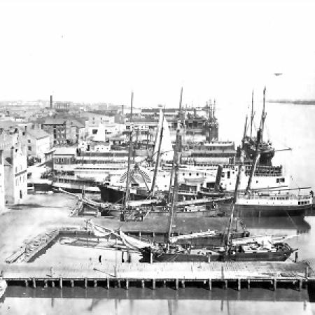
The town’s access to the deep river channel and its key position below the impassable Great Falls made it an important port in the 1700s, and later a strategic support center during the Civil War. Industry and manufacturing dominated the waterfront until the mid-1900s when the river’s value shifted to the scenic real estate and tourism of today’s Old Town neighborhood. Alexandria’s population grew and spread away from the water. New neighborhoods replaced land once used for agriculture, country estates, and Civil War fortifications. By the mid-20th century, developments and planned communities had largely altered the area.

Plan of Alexandria, 1798
Plan of the town of Alexandria in the District of Alexandria.
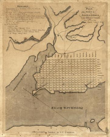
George Gilpin, 1798. Library of Congress.
View from Pioneer Mills, 1965 (Andrew J. Russel photograph, Library of Congress)
View of waterfront from Pioneer Mill, photograph by Andrew J. Russell, 1865. Library of Congress.


Four Mile Run apartments with road under water, 1963.
601 Four Mile Run Road, looking south, September 1963, photograph by Charlotte Shaver Nicols.

How have natural boundaries like water, hills, or valleys shaped your neighborhood?

Sarah O. Strother, raised in Old Town in the 1940s and 50s; interviewed by Paula T. Whitacre, August 19, 2009:

[The Riverfront at Cross Canal] was mostly free. You could go clear to the river. A lot of people sat on the banks and ate and fished or whatever…There was a pier out there, and people used to fish. They’d put them in a basket and carry them home.

Lillian Patterson, speaking about 1940s Old Town; interviewed by Krystyn Moon, May 25, 2021:

Have you heard the expression they took a sow’s ear and made a silk purse out of it? That’s Old Town.

The Bottoms: The Land that is Left

Low-lying land is historically less desirable. Recent migrants and people of lower economic status settled areas of Alexandria that would otherwise be used for industry. In the late 1700s, free Black families living on the fringes of Alexandria’s valuable waterfront held long-term rental agreements with White property owners.

The Bottoms neighborhood, later known as the Dip, was the first free Black neighborhood in Alexandria. During the Civil War, African American refugees developed new neighborhoods in similar low-lying areas, including the Berg.

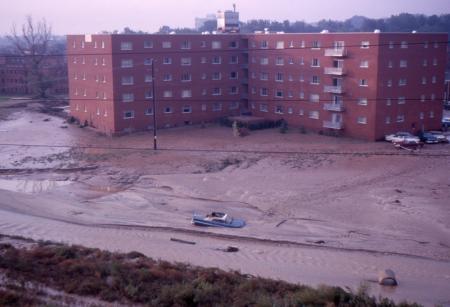
Over 200 years later, more affordable suburban developments were built within the Four Mile Run floodplain on the northern edge of the city. By the late 20th century, flooding, crime, and outdated infrastructure made the area more affordable than other neighborhoods, leading to political refugees and other migrants settling in the area now known as Arlandria-Chirilagua.


Leonard “Len” Collins; interviewed by Barbara Murray, August 1, 2012:

That whole Arlandria area would flood. And I remember as a Boy Scout we would get rowboats and we would row around assisting people who were having a problem with flooding.

Stories of a Changing City

  1. Introduction 
  2. Shaped by River & Land 
  3. We Built this City
  4. A Segregated City
  5. The City Steps In: Urban Renewal
  6. New Arrivals
  7. School Days
  8. Life in the Neighborhood
  9. Pillars of the Community
  10. Build Your Neighborhood
  11. The Oral History Map


  • Historic Alexandria
Contact Us
Alex311 | 703.746.4311
Follow Us
  • Facebook
  • Twitter
  • YouTube
Visitor Information

VisitAlexandriaVA.com

  • Emergency Hotlines
  • Social Media
  • Privacy & Legal
  • FOIA Requests
  • Departments
  • Jobs
  • Payments

Alexandria City Hall
301 King Street
Alexandria, VA 22314

City of Alexandria Seal
© 1995–2023 City of Alexandria, VA and others.
Hold on, redirecting...