Four 18th-Century Ships
As redevelopment takes place along Alexandria's waterfront, archaeologists are exploring the properties undergoing development. Archaeologists working at the Hotel Indigo site (44AX229) in 2015 uncovered a portion of the hull of a vessel, the remains of which measured nearly 50 feet. In 2018, they located the remains of three additional early ships at the Robinson Terminal South site (44AX235). Early Alexandrians sunk these vessels on the Potomac mudflats in the latter part of the 18th-century, as part of process to extend Alexandria's shoreline.
Scuttled sometime in the late 18th century, the ships served as the framework for part of the landfill process that extended the waterfront out to the deep channel of the Potomac River, helping to make the early town a thriving international port. Research by historians and City archaeologists suggested that we could find the remains of ships used in the filling process at various points along the waterfront.
The Alexandria ships project represents current research and preservation in action! The project has benefited from partnerships with the Texas A&M University’s Conservation Research Lab, the Maryland Archaeological Conservation Lab, and underwater archaeologists from Naval History and Heritage Command and the National Oceanic and Atmospheric Administration.
The City worked with Thunderbird Archeology (the consultant for the developer) to record the vessels in place. The documentation included 3D laser scanning of the 44AX229 ship and photogrammetry of the 44AX235 ships. Archaeologists also documented the ships with photography and hand drawings. City archaeologists helped Thunderbird to excavate, record, dismantle, and remove the pieces of the ship, labeling them for future study and possible conservation and reconstruction. The 44AX229 ship found at the Hotel Indigo site is undergoing conservation at Texas A&M University, while the three ships from 44AX235, Robinson Terminal South, remain submerged in water in a City warehouse, ensuring their preservation.
Ship from the Hotel Indigo Site
220 S. Union Street, site 44AX229
The first ship discovered was a 46.5 foot long by 12.5 foot wide portion of the starboard side of a wooden vessel. Construction elements of the hull were preserved in the ground including: sacrificial planking, keel, bow stem, hull planking, frames, and a small section of the interior floor boards, or ceiling. The presence of trunnels (wooden pegs called tree nails) and iron fastenings suggests that this ship was constructed in the 18th century. The ship appears to have been sturdily built with frames placed close together, likely a merchant ship carrying heavy cargo. Research by Texas A&M University’s Conservation Research Lab (the institution currently conserving the hull) suggests that the ship builders constructed the vessel for commerce and rigged it either as a sloop or more likely as a brig. The researchers estimate that the ship measured 71 feet originally, before it was chopped and broken down to size for landfill. Portions were deliberately chopped off as indicated by axe marks, and the port side (except for a few timbers) is missing.
Overlays of the changing shoreline on historic maps indicate that it was buried sometime between 1775 and 1798. Dendrochronology or the study of tree rings, reports that the timbers used to construct the ship were felled sometime after 1741 in the Massachusetts region.
The remaining conservation process is scheduled to take a few more years and the Hotel Indigo Site ship is expected to return to Alexandria in 2027.
The ship conservation is generously supported by:
- City of Alexandria
- Save Our Ship Conservation Fund
- Friends of Alexandria Archaeology
- National Park Service Maritime Heritage Grant for the 44AX229 ship, in partnership with the U.S. Department of Transportation’s Maritime Administration, $97,117
- Virginia Association of Museums Top Ten Endangered Artifacts $4,000 for the 44AX229 ship
Ships from the Robinson Terminal Site
2 Duke Street, site 44AX235
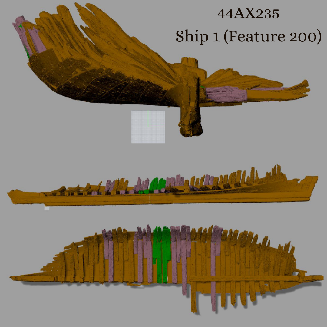
Ships 1 (Feature 200), 2 (Feature 155) and 3 (Feature 159) most likely date to the 18th century and became part of the shoreline in the late 18th or early 19th century. Initial examination suggests that all four ships (including the one discovered during construction of the Hotel Indigo) appear to be of similar construction, with tightly spaced futtocks and comparable wooden and iron fastenings. A dendrochronology report is pending.
The City is now storing the timbers of all three 44AX235 ships in tanks of water to ensure their continued stabilization. Without these measures, the wood would desiccate and disintegrate, precluding any potential for future study, documentation or conservation. The ship timbers will move to long-term storage in Ben Brenman Pond in a manner that preserves the possibility of future study and conservation when adequate funding and/or a location for permanent storage or display is available.
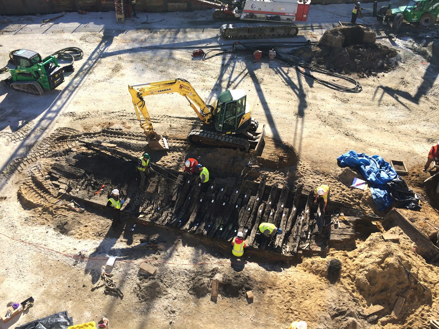
The first ship found on this block was discovered in early March, underneath the 1852 Pioneer Mill foundation. Piles from the support structure for the mill impacted the ship hull to some degree. The derelict ship had been pulled up to the original shoreline of Point Lumley, beached, and used as part of the wharf system. The stern was notched into wharf structures used for “banking out.” It was slightly listed, or tilted, on its side and oriented roughly east-west, perpendicular to the original shoreline.
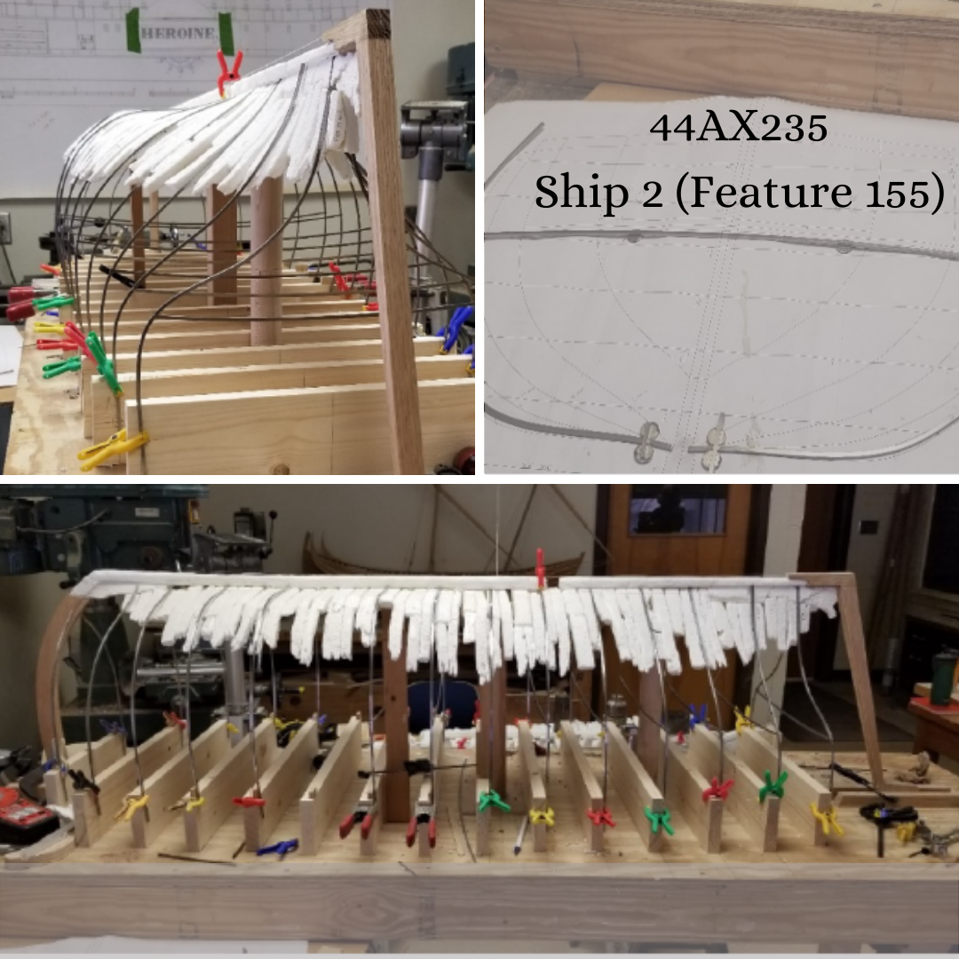
A second ship was found in mid-March, and was located closer to the Potomac River and to the southeast of the first one. It appears to run roughly parallel to the current shoreline. It was immediately north of a stone warehouse foundation and is part of the associated wharf structure. This ship appears to be intentionally notched into the adjoining wharf at both the bow and stern. A square log structure inside the hull fragment maybe associated with wharf construction or architecture. Archaeologists uncovered the hull fragment measuring roughly 46 feet long and 12.5 feet wide, consisting of 49 frames. Like the first ship, there is a mix of trunnels (or wooden pegs) and iron fasteners. Further study of this ship and the associated wharf structure may provide additional clues about late 18th-century harbor engineering.
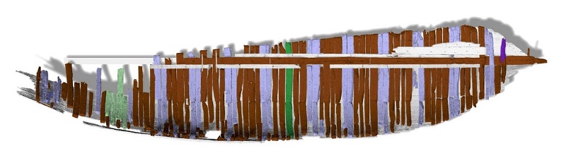
This vessel is the largest and most intact of the four ships found along the waterfront since 2015. The length of the hull runs a few degrees off the street grid and at a steep angle from west to east, suggesting the slope of the original shoreline. The hull fragment within the project area is roughly 85 feet long and about 30 feet wide at its widest point. For comparison, the other ships each measured about 50 feet in length and 15 feet in width. Because of its size, Ship 3 could have been intended to sail in the open ocean. The hull planking appears to be twice as thick as the other ships, also suggesting that this may have been an ocean-going vessel rather than one confined to coastal waters.
From what is visible, this ship does not appear to have been cut in half along the keel like the other vessels and still has both its port and starboard sides. Remains of the hull include the bow, ceiling planking, keelson, framing, futtocks, keel, and hull and sacrificial planking. Fragments of a wharf structure are set atop of the ship. Preliminary field evaluation of the materials and construction technique suggests that this vessel was built sometime in the 18th or early 19th century. A mixture of trunnels (wooden pegs) and iron fasteners hold the timbers together.
This ship was partially located underneath the current-day Wolfe Street. A resource management plan was developed that left a portion of the ship preserved under Wolfe Street for future archaeological study. Excavation of Wolfe Street would have been significant and would have created substantial safety risks for workers due to the depth of excavation and unstable perimeter slope; risked damaging underground gas, electric, and water utilities; and brought construction excavation even closer to adjacent Harborside homes. The project archaeologists developed the mitigation plan in consultation with Alexandria Archaeology, maritime archaeologists, conservators, engineers, and the developer, who explored all available options. The mitigation process involved backfilling the already exposed portions of the ship to protect them during the construction of a slurry wall that will stabilize Wolfe Street and contain the underground parking garage. Once this wall was in place, archaeologists fully excavated the exposed portion of the ship and carefully document the remains using traditional and 3D documentation techniques (photogrammetry) before the ship was dismantled and removed into water storage to prevent decay. The three are currently stable and being preserved in tanks of water while future plans are made. To maintain an option for conservation, the excavated wood has been submerged in tanks of water, allowing time for additional research, for comparison with other potential waterfront discoveries, and for identification of funding sources.
Articles and Presentations
Niculescu, Tatiana
- 2019 - "And Fill It Solidly With Brushwood and Earth or Such of Them as Would Suit Him Best": 18th and 19th Century Landmaking in Alexandria, VA. Society for Historical Archaeology (SHA) Conference Poster, January 2019.
Skolnik, Benjamin A.
- 2018 - Preserving Ships on Alexandria’s Historic Waterfront: Alexandria Archaeology and the City’s Maritime Heritage. In Toasting Our Town, Historic Alexandria Foundation.
- 2018 - Recent Maritime Archaeology on the Alexandria Waterfront. MAHSNews, Volume 29, Number 1, Spring 2018. Maritime Archaeological and Historical Society.
Learn more about Archaeology on the Waterfront.