Archaeology and Preservation
Archaeology in Alexandria began with community preservation efforts in the 1960s at Fort Ward and King Street Urban Renewal projects. The Alexandria Archaeological Commission (AAC) – the first of its kind in the United States – was established by City Council in 1975, and City archaeology staff soon followed. In the 1980s, when increasing development threatened the city's archaeological resources, the AAC partnered with the private development community to advocate for and draft the Archaeological Resource Protection Code. It passed in 1989 as the first such code in the nation.
The Code requires the evaluation of all development projects for which site plans must be filed, to determine the potential for impacting archaeological resources and whether there is a need for preservation action prior to site development. This sometimes necessitates that the applicant to the review process hire an archaeological consultant to conduct research, survey, and excavation. This procedure reduces the loss of sites and objects of antiquity that represent the cultural heritage of the nation, the commonwealth, and the city.
Alexandria Archaeology has received national awards for its leadership in the fields of archaeology and preservation.
About the Archaeological Protection Code
The Archaeological Protection Code, established in 1989, has served as a preservation model for local jurisdictions across the nation.
Through the investigation and preservation of numerous sites that would have been lost to development, the code has enabled the recovery of information about the full range of human activity in Alexandria, from Native American occupation through the early 20th century. The excavated sites highlight the wharves and ship-building activities on the waterfront; the commercial and industrial establishments, including potteries, bakeries, and breweries; life in rural Alexandria; the Civil War; cemetery analysis and preservation; and African Americans and the horrors of enslavement.
By the late 1980s, development in Alexandria was proceeding at a rapid pace, and large open spaces, such as the two abandoned rail yards, were slated for change. Concern for threatened sites across the City led the Archaeological Commission to recognize the need for a local protection ordinance to identify and preserve buried resources threatened by this myriad of development projects. The Commission sought input from the business community, especially developers and their lawyers, thereby bringing new players into partnership with archaeology. As a direct result of the Commission’s vision and commitment, City Council adopted the Alexandria Archaeology Protection Code on November 18, 1989. Not only was Alexandria’s code one of the first local ordinances in the country; it also remains one of the few local jurisdictions to consider archaeological preservation across an entire city, not merely in a historic district.
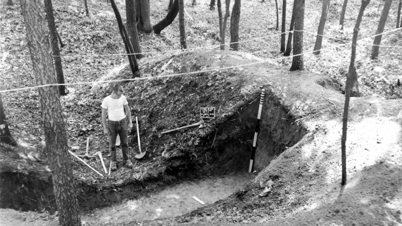
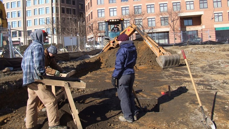
The Archaeological Protection Code set out a process whereby the private sector would pay to preserve resources and information through excavation and analysis before ground disturbance on large-scale construction projects. The code also helped to pave the way for protection and interpretation of some sites in situ. Incorporated into the City’s Zoning Ordinance, the code requires coordination with other City departments—the planners, engineers, landscape designers, and other regulatory officials who oversee the site plan process. Implementation involves review of all City development projects by staff archaeologists. The staff determines the level of work to be done by private developers who are required to hire archaeological consultants to conduct investigations of potentially significant site locations and produce both technical and public reports on their findings.
The archaeological review process necessitated the compilation of as much data as possible regarding the locations of potential sites in order to make appropriate determinations of the work levels. Using maps obtained and surveys completed through previous research efforts, City archaeologists wrote a preservation chapter for the City’s Master Plan that included over 4,000 potential site locations, as well as historic districts and standing structures. This mapped information, now in digital form with Geographic Information System software, facilitates the review process by allowing the staff to assess which projects require archaeological investigations prior to construction.
The code changed some aspects of the Alexandria Archaeology program. Research became more development-oriented and focused on threatened sites, with consultants conducting the bulk of the fieldwork. In addition to completing reviews of development projects, the staff adopted the responsibility of managing the archaeological preservation process to ensure quality, writing scopes of work, overseeing during the processes of excavation and analysis, and reviewing technical and public reports. The City’s archaeologists also direct the excavations on City development projects, coordinate with the Virginia Department of Historic Resources on federal projects, and conduct investigations of significant sites with volunteers on projects that are too small to fall subject to official code requirements.
In addition, through the partnership that has developed with planners and developers as a result of the code, the implementation process has led to the integration of history and archaeology into development projects—to bring the past out of the museum and into the streets and to incorporate it into the very fabric of the community. Interpretive markers on the Alexandria Heritage Trail relate the stories of the past. History has also found its way into public art that adorns development projects. Elements of the historical past have been saved and interpreted for the public in the city’s open spaces. And most importantly, the code has played a significant role in the creation of authentic historical spaces, such as the African American Heritage Park and Contrabands and Freedmen Cemetery Memorial, that promote an understanding of the past and enrich the lives of residents and visitors.
After more than 11,000 reviews conducted by the City’s archaeological staff, we can look back and evaluate what the code has accomplished, highlighting all the information that would have been lost without the vision of the Archaeological Commission and the foresight and action of City Council. Organized according to theme, a brief description of information recovered from some of the significant sites investigated is presented online in the Alexandria Archaeology Bibliography.
A special thanks goes out to all of the landowners, developers, planners, and archaeological consultants who have helped to save the information from these sites and contributed to making the past come alive in Alexandria.
Archaeological Protection Code and Related Documents
The Alexandria Archaeological Protection Code
The Alexandria Archaeological Protection Code is part of the City of Alexandria’s Zoning Ordinance. Read the full text.
Request for Preliminary Assessment
Completion of this Form is required for compliance with the Archaeological Protection Code.
City of Alexandria Archaeological Standards (revised October 7, 2025)
This document describes procedures to be followed by archaeological consultants working in Alexandria. The Standards includes sections on Documentary Studies, Survey and Excavation, Processing Collections, and Deliverables, including reports, associated records and collections. The Standards are periodically updated, and consultants are responsible for compliance with the latest Standards as of the date of the Scope of Work of their project. Please contact Alexandria Archaeology for the latest copy.
Archaeological Resource Management Firms
A list of consultants who have completed approved projects in the City of Alexandria in the past ten years.
Archaeological Resource Areas are like overlay Historic Districts, but for archaeology. The areas are defined as having distinct resource types relating to the history, archaeology and geology, and have a level of protection under the Archaeological Resource Protection Code. Preliminary Site Plans for development in these areas require reasonable archaeological evaluation reports and resource management plans.
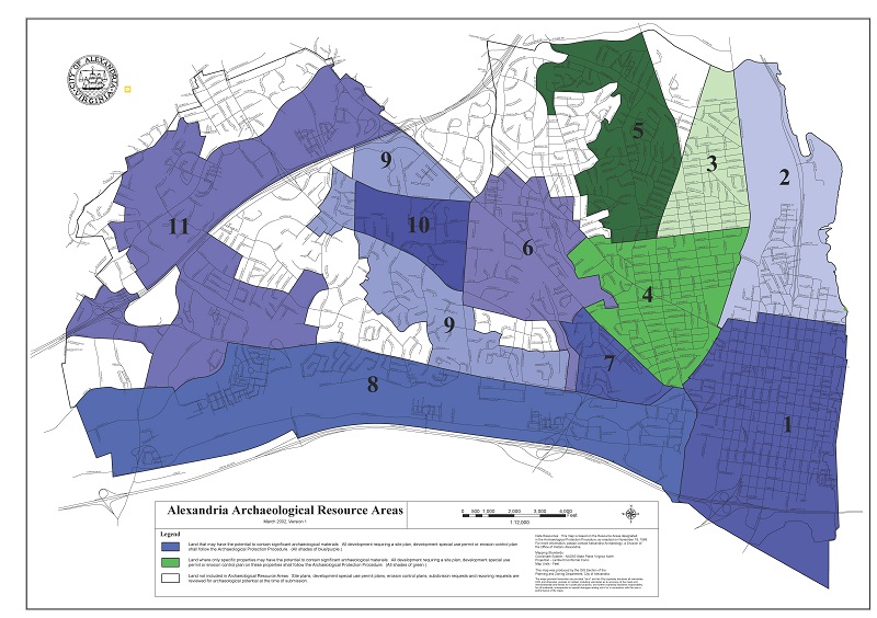
Map Legend
Blue areas: Land that may have the potential to contain significant archaeological materials: All development requiring a site plan, development special use permit or erosion control plan shall follow the Archaeological Protection Procedure.
1. Old Town
2. Potomac
6. Taylor and Timber Branch Run
7. Shuter's Hill
8. Cameron and Backlick Run
9. Outer Defense
10. Seminary
11. Holmes Run
Green areas: Land where only specific properties may have the potential to contain significant archaeological materials: All developments requiring a site plan, development special use permit or erosion control plan on these properties shall follow the Archaeological Protection Procedure.
3. Del Ray/St. Elmo
4. Rosemont/Braddock Heights
5. Mt. Ida
White areas: Land not included in Archaeological Resource Areas: Site plans, development special use permit plans, erosion control plans, subdivision requests and rezoning requests are reviewed for archaeological potential at the time of submission.
1. Old Town
The Old Town Area is the historic urban core and, since the town’s incorporation in 1749, has been the urban center for Northern Virginia. King Street was, and continues to be, a thriving commercial corridor offering wares and entertainment to the region. The area includes the historic port, production and commercial sites, churches, cemeteries, schools, and residences, including historic black neighborhoods. It also includes prehistoric sites at Jones Point, boundary markers for the District of Columbia, evidence of Civil War military occupation, and craft and industrial sites such as breweries, glass companies, furniture factories, shipyards, flour mills, brickyards, potteries and tanneries. Much of Old Town is included in a National Register Historic District.
Significance of the Old Town Resource Area
The Old Town area encompasses the original city site and generally the land laid out as blocks by 1798. A survey of the degree of ground disturbance on the blocks included within this area indicates that 72% of the land has the potential for containing archaeological resources. Excavation of more than 70 sites in Old Town demonstrates that virtually all properties contain artifacts. Excavation of a typical townhouse backyard yields approximately 25,000 artifacts. If the yard also contains a trash-filled well or privy, this number of artifacts doubles. Most Old Town properties also contain foundations of older buildings and other historic features. This segment of Alexandria is of great archaeological significance since it has sites representing the full development of the City, from the tobacco warehouses at West’s Point (Oronoco Street) to the Belle Pre Bottle Company on West Street.
2. Potomac
The Potomac Area encompasses the northern part of Old Town, Potomac Yard and tracts of undeveloped land including large parcels on Daingerfield Island. This area would have been used by American Indians for hunting and fishing. It was part of a 6,000 acre tract purchased by John Alexander in 1669. There may have been a house on Daingerfield Island prior to 1730, although much of the area was wetlands. The Alexander family plantation was built here in the 1730s, near Four Mile Run. Other plantations were established in the area in the 18th and 19th centuries. A section of the Alexandria Canal extended through the area, from the turning basin at First and Washington Streets to Four Mile Run. Potomac Yard’s large railroad freight facility was first developed in 1906. The Yard incorporated large tracts of land owned by the Swann and Daingerfield families, and its resources include the location of early homes and family cemeteries. By 1894 a neighborhood known as “St. Asaph Junction” was situated near Powhatan Street. South of the Corporation Line (midway between First and Second streets), between Washington, Patrick, Montgomery and Second Streets, was the 19th and 20th century African neighborhood known as “The Hump.” Another Black neighborhood, “Cross Canal” was located on the north side of the Canal Locks along First Street.
Significance of the Potomac Resource Area
The Potomac Area is extremely important for archaeology, since it has large areas of relatively undisturbed land that may contain American Indian sites. An early plantation and elite homes were located here, and a large section of the Alexandria Canal traversed the area. This was also a major transportation corridor, with the Alexandria and Washington Turnpike, the Alexandria, Loudon and Hampshire Railroad, and its successor the Washington & Old Dominion Railroad tracks, and Potomac Yard.
3. Del Ray/St. Elmo
From the early 18th to the mid-19th century, the Alexander family and their descendants owned and lived in this area. In the early 19th century the Alexandria and Washington Turnpike was built along the eastern boundary (Route 1). Most of the land was undeveloped or had agricultural use, although a race course was built north of Mt. Ida Avenue by 1845. Railroad tracks were laid through the area in the 1850s. By the 1870s, several farmhouses had been built on the former Alexander land. The St. Asaph Race Track was incorporated in 1888, with legal betting. Two subdivisions platted in 1894, St. Elmo and Del Ray, joined together in 1908 as the incorporated town of Potomac. Potomac exemplifies suburban growth based upon transportation development in the latter part of the 19th century. Residents commuted by train or trolley to jobs in Alexandria and with the expanding Federal government in Washington, D.C. At one time a third of the residents walked to work at the nearby Potomac Yards, a major railroad switching facility. Several houses and a Gold Bond Portable Chapel at 2701 DeWitt Ave. illustrate the commercial phenomenon of mail order buildings. The town of Potomac was annexed by the City of Alexandria in 1930, and is now a National Register Historic District.
Significance of the Del Ray/St. Elmo Resource Area
The area is significant because of the many 19th century structures that still remain as well as archaeological sites under the ground. These resources relate to the area’s early settlement and suburban life. The turnpike, canal, railroad and streetcar are evidence of an important transportation corridor. The race track site illustrates an interesting aspect of the community’s early social history.
4. Rosemont/Braddock Heights
This former Alexander land was owned by early settlers such as the Baldwin Brothers and Sybil West by the mid-18th century. At an early date, the road from Alexandria to Leesburg was constructed along what is now Braddock Road. In 1791, surveyors laid out the proposed boundary of the District of Columbia and boundary marker #2 was located near the intersection of King and Russell Road. In the 19th century larger country houses were built in the heights, such as the Anchorage and the Quinn house. The more level land toward Alexandria was characterized by smaller farms. The late 1890s saw the suburban development of Spring Park (now Rosemont) and Braddock Heights. These were streetcar suburbs like Del Ray and St. Elmo, also served by the Washington, Alexandria and Mt. Vernon Electric Railway. Rosemont is now a National Register Historic District. Its houses, the majority of which were constructed between 1908 and 1930 in a variety of styles and sizes ranging from small Craftsman bungalows to large Arts and Crafts and Colonial Revival houses, have retained exceptional architectural integrity. The original street layout of the subdivision survives, reflecting the suburban planning ideals of the City Beautiful movement.
Significance of the Rosemont/Braddock Resource Area
The area is significant because of the many 19th and early 20th century structures and archaeological resources relating to the area's early settlement and suburban life. The Old Leesburg (Braddock) Road and the electric railway are evidence of an important transportation corridor.
5. Mt. Ida
As early as 1719, a mill was built on the south bank of Four Mile Run. In 1800, a sixth generation descendent of John Alexander built the house known as Mt. Ida. After the Civil War, the “Gingerbread House” was built on an adjoining property. Other ante-bellum houses included Mt. Auburn, Warwick, and the Russell and Fractius farms. Military maps from the Civil War show a cemetery in the vicinity of Park Fairfax and several smaller farmsteads in other locations.
Significance of the Mt. Ida Resource Area
The area is significant because of the many remaining 19th century structures and archaeological resources under the ground. These resources relate to the area's early settlement and suburban life. The railroad and electric railway are evidence of an important transportation corridor.
6. Taylor and Timber Branch Run
Two streams, Taylor and Timberbranch Run, flow through this area. During prehistoric times, wildlife was attracted to these water sources and as a result, the stream valleys became hunting grounds for Native Americans. Evidence of temporary hunting camps has been found in the form of stone tools and flakes produced during their manufacture, and cracked rocks resulting from the heat of camp fires. The land was patented in 1678 by John Carr and John Simpson, who may have built a residence in this area and farmed the land. By the 1760s prominent Alexandrians including William Ramsay and John Carlyle owned land within this area. They lived in the Old Town area, with tenants or overseers and slaves working their farms. Three major transportation arteries – the Alexandria Leesburg Turnpike (King Street), the Old Leesburg Road (Braddock Road) and Quaker Lane – converge in the northwest corner of this area. A tollgate was located on the Turnpike near this intersection, and by 1861 half a dozen houses stood nearby. An historic African American community, “Macedonia,” was located where T.C. Williams High School now stands. On Circle Terrace, a house and dairy farm known as “Oakland” was built in 1888. Two cemeteries were situated in this area, including Ivy Hill that still can be seen on King Street.
Significance of the Taylor and Timberbranch Run Resource Area
This area is significant because it contains important sites from virtually all time periods. Potential archaeological resources include American Indian hunting camps, early farms both large and small, two cemeteries, and an African American community. Two major roadways traverse this area and acted historically as the connection between Alexandria and the countryside to the west.
7. Shuter's Hill
Shuter's Hill is the high land west of Old Town, where the George Washington Masonic Memorial now stands. This area is bounded by two turnpikes, The Alexandria Leesburg Turnpike (King Street) and the Little River Turnpike (Duke Street). In the 1760s, John Alexander owned this land. About 1781, a two story frame mansion was built, which was later used as a summer residence. It burned to the ground in 1843, and in the 1850s, a brick mansion was built nearby. In 1851, the Alexandria Water Company’s reservoir was built on the hill. At the start of the Civil War, Fort Ellsworth was built on the hill as part of the Defenses of Washington. The fort included 29 guns, bomb-proofs, powder magazines, and two wells. Barracks were built on the east side, and the brick mansion was used for military purposes. A Civil War period house still stands on Janney’s Lane, and many of the walls are covered with graffiti from the soldiers. A tollgate stood at the intersection of King Street and Janney’s Lane, described as old on an 1887 plat. In 1907, a large part of the hill was developed as a high income residential area. Ground was broken for the Masonic Memorial in 1922, with work completed a decade later.
Significance of the Shuter's Hill Resource Area
This area is highly significant for containing resources relating to 18th century and later residential settlement, Civil War period defensive structures and early road development. The site of Fort Ellsworth and its associated entrenchment lines offer perhaps the greatest resources left in Alexandria for gaining knowledge of Civil War defensive structures.
8. Cameron and Backlick Run
This area has a long and complex history which includes nearly all phases of Alexandria’s development. Backlick Run, Holmes Run, Cameron Run, and Hooff’s Run create riverine environments that attracted much wildlife and offered prime hunting grounds for American Indians. Cameron, a small settlement that predated Alexandria, was probably situated at the head of Hunting Creek. John Carlyle and other early founders of Alexandria lived in this hamlet. If the Virginia Assembly had selected the Cameron petition instead of Hugh West’s in 1749, the new port town would have been established near the intersection of Telegraph Road and Cameron Run, rather than at the foot of Oronoco Street on the Potomac River.
A mill was established in the vicinity of Cameron by 1752. Prior to 1798 a second mill, Cameron Mills, was constructed nearby. A long millrace provided water power for the mills, with a viaduct carrying the millrace over Taylor Run. One of the early mills was incorporated into the Alexandria Water Company in 1851. Near the Water Company’s reservoir on Shuter’s Hill stood Cameron Mills Farm. A 19th century distillery was located north of Mill Road and west of Telegraph, and two Civil War period entrenchments ran just west of the distillery. Union blockhouses were built south of this area and near Duke and Colvin Streets. Other mills in this area include ones dating to 1733 and 1760. One building from the Brown’s Mill complex still stands on Wheeler Avenue.
The Little River Turnpike operated as a toll road from 1806 to 1896. The “West End,” a village just outside Alexandria’s 19th century town limits, clustered along Little River Turnpike from Hooff’s Run west to the toll gate. Homes, businesses, the Bruin slave pen, Catts’s Tavern, a brewery, slaughterhouses, many butchers, and the toll gate were once located on the 1400 to 2000 blocks of Duke Street. A stone bridge spanned Hooff’s Run at Duke and Peyton Streets.
The western section of this area was scattered with small farms and one large plantation, Bush Hill. Established in 1797, the plantation included a 12-room dwelling, overseer house, slave quarters, brick barn, frame granary, cow and sheep shelter, log corn house, blacksmith shop, seed house, carriage house, chapel, icehouse, smokehouse, limekilns, greenhouses, family cemetery and slave burial ground. In the 1850s the Orange and Alexandria railroad was built in the southern part, and two cattle stops were built beside the tracks on Bush Hill land.
Significance of the Cameron and Backlick Run Resource Area
This area is one of the most likely places in Alexandria to contain evidence of American Indian life. The filling of certain areas within the Eisenhower Valley may provide a protective cover to Indian sites dating back 10,000 years. From the 1740s, this area served as a connection between Alexandria and the west. The Turnpike, a major mill race and the railroad traversed this region. At least five mill complexes operated here. The remains of these resources, as well as the early village of Cameron, may still be extant underground.
9. Outer Defense
This rural area had a history of agricultural production, country estates, and military defenses. It also served as a major transportation corridor, connecting Alexandria with the west. American Indians left traces of hunting camps, some dating back 10,000 years. European settlement came in the early 18th century when small farmsteads were established. There were at least four country estates in this area.
Prospect Hill stood on the current site of Bradlee Shopping Center, near a major intersection of the Alexandria Leesburg Turnpike (King Street) and the Old Leesburg Road (Braddock Rd.). By 1861 a cluster of houses surrounded the crossroads. To the west was the mid-19th century Monokin estate, which survived into the 20th century. The Vauxcleuse estate was destroyed in 1861, rebuilt in 1901 and demolished in 1972 to provide parking for the Alexandria hospital. Transportation arteries included Duke Street, an 18th century country road that became a toll road (Little River Turnpike) in 1806, and the Leesburg Turnpike (King Street), built in 1813. The Orange and Alexandria was completed in 1859.
The Civil War had a major impact on this area. From 1861-1865 the Cameron Run Valley was scattered with semi-permanent troop encampments that destroyed local agricultural production and decimated the woodlands. Three major forts and 10 batteries from the Defenses of Washington were located in this area, along with miles of entrenchments. Fort Worth was built on the site of “Muckross,” home of Confederate Colonel Arthur Herbert. This home was rebuilt after the war, using one of the stone powder magazines as its basement. Another Confederate officer’s estate, “Cameron,” was the site of Fort Williams. Bricks from the house were used to build a powder magazine that is still extant.
Significance of the Outer Defense Resource Area
This area is significant for its American Indian hunting grounds, 18th and 19th century agricultural settlements and country estates. This area includes the majority of Civil War defense remains still preserved in Alexandria. While most of the above ground structures no longer exist, many resources may still lie underground.
10. Seminary
The Seminary Area is a relatively undisturbed tract of land in the center of Alexandria composed of the property of the Virginia Theological Seminary and Episcopal High School. Three major roads form the boundaries: Braddock Road, Quaker Land and Seminary Road. The remains of American Indian hunting camps may be located in this area, but the first recorded settlement began in the 19th century. The Seminary was founded in the early 19th century, stemming from the Educational Society and the School of Prophets. In 1827 Jonah Thompson sold his estate, “Oakwood,” to the Seminary. The home is still in use today. Another large mansion, “Araby,” once stood near the intersection of Stadium Drive and Braddock Road. Other significant 19th century structures are still in use, including Melrose Abbey and Aspin Wall Hall. A small frame building on Seminary Road continued to be used as a post-office until a few years ago. During the Civil War these grounds and buildings were used as a Union headquarters and a staging area for troops.
Significance of the Seminary Resource Area
The Seminary Area is one of the most significant properties in the City. It has many historic buildings, and large sections of relatively undisturbed land which may contain archaeological resources. The Civil War had a major impact on the Seminary. Its buildings were used for Union headquarters, five batteries and entrenchments were constructed along the western boundary, and troops camped on the grounds.
11. Holmes Run
This area, located farthest from the core settlement of Alexandria was historically a sparsely settled agricultural community. The remains of hunting camps, dating as early as 10,000 years ago, have been found in many areas. Twenty of these sites have been registered with the Virginia Department of Historic Resources. John Carlyle’s plantation, “Tortherwald” (later “Morven”) dates to 1756 and covered 640 acres. A three-story house was built by 1770 and stood until the 1930s. The estate included a detached kitchen, overseer’s house, meat-house, barn, stables for 27 horses, cow house, dairy, weaver’s shop, smithy, grist mill and miller’s house. “Oakland” was built in 1741 by William Henry Terrett, and still stands at Palmer Place. The Strathblane estate included a family cemetery and a large home used during the Civil War as headquarters for Camp California. Mills and mill races, including Cloud’s Mill, were constructed in the 18th and 19th centuries. Union Forces launched observation balloons in this area, to follow the movements of Confederate forces in the Springfield area. A battery of two guns at the north end of an entrenchment line extends south to Fort Ward. The community of Lincolnia, in the southwest corner of this area, was established in the late 19th century. The Lincolnia Cemetery contains graves from the 19th and 20th centuries.
Significance of the Holmes Run Resource Area
The area was a hunting ground for American Indians and a sparsely settled agricultural region in colonial times. Until the 20th century, the area remained a rural hinterland. John Carlyle, a founder of Alexandria, established a farm in this area and exemplified the connection between the rural and urban communities. Because of the relatively sparse populations and large tracts of undeveloped land, the Holmes Run Area offers high potential for containing many prehistoric and historic archaeological sites.
Ordinance 3413
City Council Resolution establishing the Archaeological Protection Code, 1989
Senate Joint Resolution No. 198
State Resolution commending the 20th anniversary of the City's pioneering Archaeological Protection Code.
Permit Review
Alexandria Archaeology reviews all building permits and other code enforcement permits that involve ground disturbance. On projects which do not require site plans (such as small additions to private homes), we may ask property owners to allow City archaeologists and volunteers to excavate prior to construction or to monitor the site during construction. Alternatively, we may ask that the owners call us if artifacts or features are found.
Metal Detecting Code
Metal Detecting and removal of property of any kind is ILLEGAL on public land, including City, State and Federal parks and property. Illegal activities on public lands include collecting artifacts along the shorelines and streambeds and removing plants, as well as metal detecting and excavation. The Alexandria City Code prohibits metal detecting, digging, or removal of objects on City property.
The Metal Detecting Code is included in the Code of the City of Alexandria Chapter 1, Title 13 Section 13-1-40
Backyard Archaeology
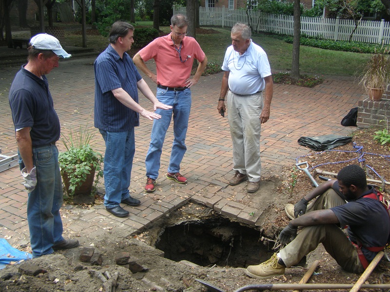
What can home and business owners can do when they encounter sinkholes or small circular depressions in their backyard? These backyard features may be the buried remains of historic wells or privies. As archaeologists, we want to protect and save them!
What can you as a steward of Alexandria’s history do if you find one of these in your backyard? This step-by-step guide shows how you can save history, fix your sinkhole, and become one of Alexandria’s Archaeology Protectors.
Reports of Preservation Projects
Investigations produce reports, which include the technical results of the projects and their interpretation, as well as artifacts, preserved as part of the City’s Alexandria Archaeology Museum collection. Other archaeological inquiries in Alexandria not initiated by the Code also yield reports and artifacts, most of which are part of the collection. Thus, while not all sites are protected, they do live on through their information and material culture in spite of the passage of time and persistence of development. Over the years, the reports have been filed at the Museum, with copies provided to the City Library, and artifacts housed in the City's repository. Yet few know of the reports that have been published. In an attempt to bring the “gray literature” to light, most of these archaeological reports, spanning six decades of archaeology in Alexandria and chronicling thousands of years of history across the city, now are available for download as PDFs. New reports will be added online as they are processed.
The site reports are listed alphabetically in the Alexandria Archaeology Bibliography, or by location on the Alexandria Archaeology Report Finder. If a Virginia site registration number exists for a project, then it, too, is listed. Each entry includes a link to PDF (or PDFs) of the report and a report summary, where provided. The summaries also provide related reports and/or recommendations for further reading. The bibliography also includes some historical, architectural and artifact studies pertaining to Alexandria sites.
GIS Tools for the Archaeologist
The use of GIS improves the efficiency and accuracy of the review process, thus enhancing Alexandria’s historic preservation efforts. Historical maps and aerial photographs are scaled to serve as layers within the City’s Geographical Information System in order to predict topographical locations of Native American occupation and to identify the locations of historic sites on the contemporary maps. Alexandria Archaeology worked with the Center for Geospatial Information Technology at Virginia Tech, and with the City of Alexandria’s GIS Division in the Department of Planning and Zoning, to develop historical map layers.
As a result of the archaeological review process, many sites have been investigated, and a wide variety of important information has been made available to the public. The kinds of sites and resources explored and preserved as a result of the Code include Native American camps, tenant farmsteads, Civil War encampments, plantations, cemeteries, African American homes, and businesses, including a sugar factory, a ropewalk, grist mills, potteries and glassworks.
To protect archaeological sites from potential looting, some of the map layers will only be used in-house, and will not be made available to the public. The exact location of archaeological sites is protected and is not subject to the Freedom of Information Act. Federal and State governments restrict this information, and ask that we do the same. We may make location information available when the site is no longer extant because of archaeological excavation and subsequent development.
GIS overlays allow City archaeologists to identify locations of important historic sites in the modern landscape, and to make decisions about where archaeological investigations need to be conducted prior to development.
This GIS map shows a Civil War map, Environs of Washington, from the National Archives, as an overlay on the modern City map which shows streets and property boundaries. We can also add layers on the modern map showing existing buildings, sewer lines and other features. The map, which covers the entire City, was digitized and “rectified”, or made to fit as closely as possible to the modern City map, by matching known points on the old and new maps.
The Digital Atlas includes historical maps and aerial photographs, as well as resource maps developed by Alexandria Archaeology staff and volunteers. Before the Atlas was developed, Archaeologists consulted paper copies of these maps each time they needed to evaluate a property slated for development. All development requiring Site Plans and Special Use Permits are reviewed in accordance with the Alexandria Archaeology Protection Code. Archaeologists also review all building permits.
As each map is added to the Atlas, the evaluation process becomes easier. The maps are seen as layers on top of the modern City map, and various layers can be turned on and off. We can zoom in to a property and look at features on the early maps in relation to existing buildings.
Here are a few examples of maps included in the Digital atlas. Some layers are complete, and others are still being added to the Atlas.
These maps are from the City’s Master Plan. In 1992, Alexandria Archaeology created a series of 14 Small Area Plans with maps showing known or possible locations of historic and archaeological resources in each area of the City. These were compiled from a variety of historical and archaeological sources.
These are used for preservation in Old Town. The 35 Thematic Maps were created from a variety of historic sources, each indicating known or possible sites related to prehistory, African American businesses, cemeteries, Quakers, the Civil War, the Fire of 1827, and other topics. These maps, with an underlying database, are gradually being added to the Digital Atlas.
The Civil War Environs of Washington (shown here) was the first historic map layer created for the Atlas. Layers have also been created from the Civil War Quartermaster Maps, and from portions of Alexandria maps from 1748, 1749, 1790 and 1849.
Changes in the City over time can be seen in a series of aerial photographs from 1927, 1937 (shown here) and the 1950s. The 1927 map (shown here) was the first to be included in the Atlas. The GIS Division has also posted aerial photos from 1995 to 2006, taken approximately every two years.
The Hopkins and Sanborn Companies created detailed fire insurance maps of American Cities. The Hopkins Insurance map from 1877 (shown here) is our earliest insurance map. The waterfront portion is currently included in the Atlas.
The Alexandria Archaeology Report Finder is an interactive map is designed for finding archaeological reports and exploring the research conducted throughout the City of Alexandria.
Archaeology at the Virginia Department of Historic Resources
Both State and Federal laws and procedures require that significant archaeological sites be identified and considered in a variety of public projects. As the State Historic Preservation Office (SHPO), VDHR assists state and federal agencies in meeting their responsibilities.
Federal Laws and Regulations on Archaeological Preservation
For more information about Federal laws, and on archaeology and preservation programs of the Federal government, visit the National Park Service website.
- The Antiquities Act of 1906 gives the government the power to protect antiquities on federal lands, and gives the President authority to establish national monuments and historic sites to protect them.
- The National Historic Preservation Act (NHPA) of 1966 recognizes a federal interest in encouraging the preservation of culturally significant resources through public and private efforts. Central to the accomplishment of the goals of this act is the National Register, a current listing of districts, sites, buildings, structures and objects deemed significant in American history, architecture, archaeology and culture. Section 106 of this Act provides for archaeological studies of federally funded or licensed projects.
- The Archaeological Resources Protection Act (ARPA) of 1979 clarified the scope of protection and expanded penalties for violations of the Antiquities Act. Stealing and vandalism of antiquities on federal lands is a criminal offense punishable with fines up to $100,000 and five years in prison.
- The Abandoned Shipwreck Act of 1987 provides for the protection and cultural management of abandoned shipwrecks.
- The Native American Graves Protection and Repatriation Act (NAGPRA) of 1990 requires Federal agencies and museums that receive Federal funds to complete inventories and summaries of Native American human remains, funerary objects, sacred objects and objects of cultural patrimony, to notify Indian tribes or Native Hawaiian organizations in regard to these collections, and to repatriate the return of such items at the request of affiliated tribes.
- The Curation of Federally-Owned and Administered Archaeological Collections (36 CFR Part 79) is a Department of the Interior regulation passed in 1990 which establishes procedures for the care and preservation of archaeological collections.