You're logged in with MyAlex  |  Logout

City of Alexandria, VA

Search results cleared

Include archived pages
Most of the content here is written in English. Translate your search to find more content? Translating "" to English... Searching for English phrase ""
  • Live
  • Play
  • Services
  • Business
  • Government
  • Projects & Plans
  • Calendar
  • I want to…

Wayfinding: The Port City

When Alexandria was founded in 1749, the new town was perched on a high bluff above a crescent-shaped bay that extended inland to current-day Lee Street. Efforts to fill the muddy bay began immediately to extend the shoreline of the newly founded town to the deeper river channel. By 1798, the shoreline extended two full blocks into the river to create the “Port City.” Archaeologists have excavated remnants of the early wharves that extended out into the river to reach the channel.
Page updated on December 29, 2021 at 1:21 PM

Historic Sites

  • About Historic Alexandria
  • City Museums
    • Alexandria Archaeology Museum
    • Alexandria Black History Museum
    • Alexandria History Museum at The Lyceum
    • Fort Ward Museum & Historic Site
    • Freedom House Museum
    • Friendship Firehouse Museum
    • Gadsby's Tavern Museum
    • Stabler-Leadbeater Apothecary Museum
  • City Historic Sites
    • Alexandria African American Heritage Park
    • Alexandria Union Station
    • Contrabands and Freedmen Cemetery Memorial
    • Lloyd House
    • Murray-Dick-Fawcett House
    • The Fort: A Post-Civil War African American Community
  • African American History Division
  • Alexandria Oral History Center
  • Archives and Records Center
  • Commissions Supporting Historic Alexandria
  • More Historic Sites
    • African American Heritage Trail
    • Del Ray and the Town of Potomac
    • Historic Cemeteries
    • Union Hospitals during the Civil War
    • Wayfinding: Historic Signs
  • News Releases
  • Stay Connected
  • Support Historic Alexandria
    • Make a Gift
    • Become a Member
    • Join a Commission
    • Volunteer

Share

Share on Twitter Share on Facebook
Translate icon
Translate icon
XWARNING: You have chosen to translate this page using an automated translation system. This translation has not been reviewed by the City of Alexandria and may contain errors.

The Port City

Wayfinding sign, The Port City

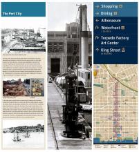
From this point, King Street slopes gently down to the Potomac. But when Alexandria was founded in 1749, the new town was perched on a high bluff some 20 feet above the river. The town was established on the shore of a crescent-shaped bay that extended inland to current-day Lee Street, then called Water Street. The steep banks that rose above the shoreline extended from Hugh West’s 1732 tobacco inspection station and warehouse, at the foot of Oronoco Street, southward to Point Lumley, near the foot of Duke Street. Between 1732 and 1749, the only roadway coming through the area was the old “Rolling Road” from the west, used to roll round “hogsheads” of tobacco to West’s warehouse for transport on the river.

In the early years, erosion from tree removal, brick making, and cultivation caused silt to wash into the river, making it difficult for large ships to navigate the shallow waters that developed along the shore. Efforts to fill the muddy bay began immediately to extend the shoreline of the newly founded town to the deeper river channel. Cliffs were cut and “banked out,” pushing land out onto the hard flats of the riverbed. Excess soil from newly built roads and structures added to the fill, as did discarded ships, ballasts, road run-off, household trash and other wastes. By 1798, the shoreline extended two full blocks into the river to create the “Port City.” Archaeologists have excavated remnants of the early wharves that extended out into the river to reach the channel.

Read the sign.

Where to find this sign

In Old Town, mini kiosks are located at designated intersections along King Street, Cameron Street, and the Waterfront to provide an orientation for pedestrians. 

This wayfinding sign is located on King at N. Lee Street. (For those taking the King Street Trolley, please check the schedule as times may have changed.)

See all the wayfinding signs on and around King Street.


  • Historic Alexandria
  • Historic Sites
Contact Us
Alex311 | 703.746.4311
Follow Us
  • Facebook
  • Twitter
  • YouTube
Visitor Information

VisitAlexandriaVA.com

  • Emergency Hotlines
  • Social Media
  • Privacy & Legal
  • FOIA Requests
  • Departments
  • Jobs
  • Payments

Alexandria City Hall
301 King Street
Alexandria, VA 22314

City of Alexandria Seal
© 1995–2023 City of Alexandria, VA and others.
Hold on, redirecting...