You're logged in with MyAlex  |  Logout

City of Alexandria, VA

Search results cleared

Include archived pages
Most of the content here is written in English. Translate your search to find more content? Translating "" to English... Searching for English phrase ""
  • Live
  • Play
  • Services
  • Business
  • Government
  • Projects & Plans
  • Calendar
  • I want to…

Wayfinding: Port City

Alexandria, the “Port City” on the Potomac, was one of the largest ports in the United States in the 1790s. In the West End, Commerce Street connected Duke and King streets at an angle, to facilitate the passage of farm wagons from the agricultural lands in the west to waiting ships on the Alexandria waterfront.
Page updated on December 29, 2021 at 1:19 PM

Historic Sites

  • Historic Alexandria (Home)
  • About Historic Alexandria
  • City Museums
    • Alexandria Archaeology Museum
    • Alexandria Black History Museum
    • Alexandria History Museum at The Lyceum
    • Fort Ward Museum & Historic Site
    • Freedom House Museum
    • Friendship Firehouse Museum
    • Gadsby's Tavern Museum
    • Stabler-Leadbeater Apothecary Museum
  • City Historic Sites
    • Alexandria African American Heritage Park
    • Alexandria Union Station
    • Contrabands and Freedmen Cemetery Memorial
    • Lloyd House
    • Murray-Dick-Fawcett House
    • The Fort: A Post-Civil War African American Community
  • African American History Division
  • Alexandria Oral History Center
  • Archives and Records Center
  • Commissions Supporting Historic Alexandria
  • More Historic Sites
    • African American Heritage Trail
    • Del Ray and the Town of Potomac
    • Historic Cemeteries
    • Union Hospitals during the Civil War
    • Wayfinding: Historic Signs
  • News Releases
  • Stay Connected
  • Support Historic Alexandria
    • Make a Gift
    • Become a Member
    • Join a Commission
    • Volunteer

Share

Bluesky Share on Facebook Share on X Share via Email
Translate icon
Translate icon
XWARNING: You have chosen to translate this page using an automated translation system. This translation has not been reviewed by the City of Alexandria and may contain errors.

Port City

Wayfinding sign, Port City

Historically, Alexandria’s development moved from east to west, and three distinct areas of the city have unofficially been known as the “West End.” The first West End ended at Shuter’s Hill, the current site of the George Washington Masonic National Memorial. In the 1930’s, the second West End extended to Quaker Lane, about two miles west of the Memorial. The final West End moved about four miles further west in 1952, to an area just beyond what is now Beauregard Street. Interestingly, each area has been so identified not only by its geographical proximity to the rest of the city, but also its association with separate families, all named West.

Commerce Street was a rare diagonal street in Alexandria’s first West End, which connected Duke and King Streets at an angle. Further west in Fairfax County, Duke Street changes its name to Little River Turnpike, an early colonial road that originally linked Northern Virginia’s vast agricultural lands with Alexandria, also known as “Port City,” on the Potomac. Wagons filled with tobacco, wheat, corn and other grains traversed this road on their way to the waterfront warehouses and docks. In 1793, Alexandria ranked as the third largest exporter of wheat and grains in the United States, and by 1797, it had become the 7th largest port in the United States.

The short angled passage at Commerce Street was created and named specifically to facilitate commerce and trade in the growing city by eliminating the need for farm wagons to make sharp right angle turns within the city’s existing street grid. Land for the street was conveyed to the town on January 1, 1798, by John Dundas, Abraham Faw and Francis Peyton to allow for construction of the roadway, thereby allowing the large wagons to maintain their speed and make gradual turns while heading to the waterfront.

Read the sign.

Where to Find This Sign

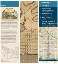
In Old Town, mini kiosks are located at designated intersections along King Street, Cameron Street, and the Waterfront to provide an orientation for pedestrians. 

This wayfinding sign is located on the south side of King at Fayette Street. (For those taking the King Street Trolley, please check the schedule as times may have changed.)

See all the wayfinding signs on and around King Street.


  • Historic Alexandria
  • Historic Sites
Contact Us
Alex311 | 703.746.4311
Follow Us
  • BlueSky
  • Facebook
  • X
  • YouTube
Visitor Information

VisitAlexandriaVA.com

  • Jobs
  • Payments
  • Departments
  • Newsroom
  • Social Media
  • Emergency Hotlines
  • Accessibility
  • FOIA Requests
  • Privacy & Legal

Alexandria City Hall
301 King Street
Alexandria, VA 22314

City of Alexandria Seal
© 1995–2023 City of Alexandria, VA and others.
Hold on, redirecting...