Wayfinding: Electric Railway
Electric Railway

Alexandria’s electric streetcar system, the Washington, Alexandria & Mount Vernon Railway, was established in 1892 between Alexandria and Mount Vernon. In 1896, the line extended into Washington, crossing the Long Bridge where the 14th Street Bridge is today.
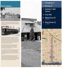
The line traveled from Mount Vernon Estate into Alexandria, up South Royal Street and for a time, South Fairfax Street, to King Street, then west to Commonwealth Avenue and north across Four Mile Run, into Arlington and then Washington. The tracks on King Street once reached across Union Street to the waterfront but in 1910 they ended at Fairfax Street. Between Columbus and Payne Streets, streetcars ran one-way with opposite direction tracks on Cameron Street. This photograph, probably taken in the 1920s, shows a car on North Columbus Street near Cameron Street.
The stops in Alexandria, and beyond in Del Ray which was then located outside the city limits, allowed connections to railroads operated by Southern and Washington & Old Dominion. They also encouraged the growth of Del Ray, St. Elmo, and Rosemont as streetcar suburbs, served by several stops along Commonwealth Avenue.
Trains ran regular schedules, traveling from Alexandria to Washington about twice an hour between 6 a.m. and 11 p.m., Monday through Saturday, with less frequent service on Sunday. In 1906, 30 daily trains between Mount Vernon and Washington carried 1.7 million passengers, a number that was likely boosted by the opening of an amusement park along Four Mile Run with its own station.
By 1930, as automobiles gained in popularity and roads were improved to accommodate them, service to Mount Vernon was abandoned south of Alexandria to make way for the George Washington Memorial Parkway. Soon the Federal Triangle development in Washington resulted in condemnation of the railway station there, leaving streetcars from Virginia without a Washington station. On April 9, 1932, the electric railway service ended.
Where to find this sign
In Old Town, mini kiosks are located at designated intersections along King Street, Cameron Street, and the Waterfront to provide an orientation for pedestrians.
This wayfinding sign is located on King at S. Royal Street, across from City Hall. (For those taking the King Street Trolley, please check the schedule as times may have changed.)
See all the wayfinding signs on and around King Street.