You're logged in with MyAlex  |  Logout

City of Alexandria, VA

Search results cleared

Include archived pages
Most of the content here is written in English. Translate your search to find more content? Translating "" to English... Searching for English phrase ""
  • Live
  • Play
  • Services
  • Business
  • Government
  • Projects & Plans
  • Calendar
  • I want to…

Alexandria Canal FAQ

The Alexandria Canal connected the city's wharves on the Potomac to the Chesapeake & Ohio Canal (C&O) in Georgetown. It opened in 1843 and ceased operation in 1886. Learn more about the construction of the canal, its use during the 19th century, and which portions have been excavated by archaeologists.
Page updated on May 12, 2025 at 1:45 PM

Historic Sites

  • Historic Alexandria (Home)
  • About Historic Alexandria
  • City Museums
    • Alexandria Archaeology Museum
    • Alexandria Black History Museum
    • Alexandria History Museum at The Lyceum
    • Fort Ward Museum & Historic Site
    • Freedom House Museum
    • Friendship Firehouse Museum
    • Gadsby's Tavern Museum
    • Stabler-Leadbeater Apothecary Museum
  • City Historic Sites
    • Alexandria African American Heritage Park
    • Alexandria Union Station
    • Contrabands and Freedmen Cemetery Memorial
    • Lloyd House
    • Murray-Dick-Fawcett House
    • The Fort: A Post-Civil War African American Community
  • African American History Division
  • Alexandria Oral History Center
  • Archives and Records Center
  • Commissions Supporting Historic Alexandria
  • More Historic Sites
    • African American Heritage Trail
    • Del Ray and the Town of Potomac
    • Historic Cemeteries
    • Union Hospitals during the Civil War
    • Wayfinding: Historic Signs
  • News Releases
  • Stay Connected
  • Support Historic Alexandria
    • Make a Gift
    • Become a Member
    • Join a Commission
    • Volunteer

Share

Bluesky Share on Facebook Share on X Share via Email
Translate icon
Translate icon
XWARNING: You have chosen to translate this page using an automated translation system. This translation has not been reviewed by the City of Alexandria and may contain errors.

What is a canal?

A canal is a manmade waterway. People built canals to transport goods and resources because it was easier to float them over water than to pull them over land by horse and wagon. Unpowered canal boats were often pulled by mules or horses walking a parallel towpath. Boats and barges were sometimes powered by steam as well. Locks and aqueducts allowed the boats to follow a more direct route, change elevation along the way, and travel the canal in both directions.  

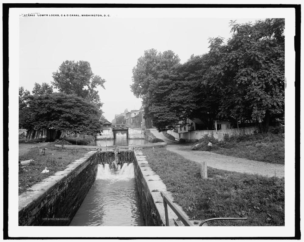
Lock: A lock is a small section of a canal that raises or lowers the water level, much like an elevator, allowing boats to navigate changes in elevation, including traveling uphill. 

Basins/Pool: Wider sections of the canal are known as pools or basins. Basins served as storage reservoirs for canals, providing water for the locks. They also provided space for boats to load, unload, change direction, and wait for passage through a lock.  

Aqueduct: Canal aqueducts are bridges for boats. They allow canal barges to cross both deep and swift river channels.  

A black and white photo shows a narrow lock with gates in the background allowing water to enter from the larger basin beyond.
Black and white photo of two canal boats in a canal paralleling the Potomac River. A towpath is visible in the foreground.
Photo showing a canal boat leaving the C&O Canal in Georgetown and entering the Alexandria Aqueduct to cross the Potomac River towards Alexandria.
of
Grid View Close Modal
A black and white photo shows a narrow lock with gates in the background allowing water to enter from the larger basin beyond.
C&O Canal lock in Washington, D.C. filling with water from the wider basin in the background, between 1910 and 1920. (Courtesy of Library of Congress, Prints and Photographs Division)
Black and white photo of two canal boats in a canal paralleling the Potomac River. A towpath is visible in the foreground.
Canal boats on the C&O Canal with the Potomac River in the background. (Courtesy of Library of Congress, Prints and Photographs Division).
Photo showing a canal boat leaving the C&O Canal in Georgetown and entering the Alexandria Aqueduct to cross the Potomac River towards Alexandria.
Aqueduct Bridge at Georgetown with the Chesapeake and Ohio (C&O) Canal in the foreground and the Alexandria Canal at Rosslyn in the background, ca. 1868.

Why was the Alexandria Canal built?

In the late 18th and early 19th century, canals increased access to inland trade and connection to the growing western frontier. Unlike roads, they were an efficient way to move large amounts of goods across great distances. Railroads eventually won the 19th century transportation war as a cheaper and faster means of transport.  

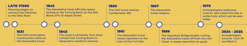
Initial plans for the Chesapeake & Ohio Canal (C&O) promised a route between the Potomac River and the Ohio River in Pittsburgh. Construction began in 1828, but the finished canal only made it as far west as Cumberland, MD and terminated at nearby Georgetown, cutting out Alexandria and threatening its position as a key player in the river trade.  

The town sought economic advantage by building the Alexandria Canal as a connecting spur to the C&O to reclaim their position as an economic power in the region. Competition was tight, but unlike neighboring Georgetown, Alexandria had the benefit of a deep-water port for merchant ships and locks that allowed the canal boats to reach the wharves along the Potomac.  

1838 map showing Alexandria, Georgetown, and the Potomac River, with a labeled overlay of the Alexandria Canal and C&O Canal.

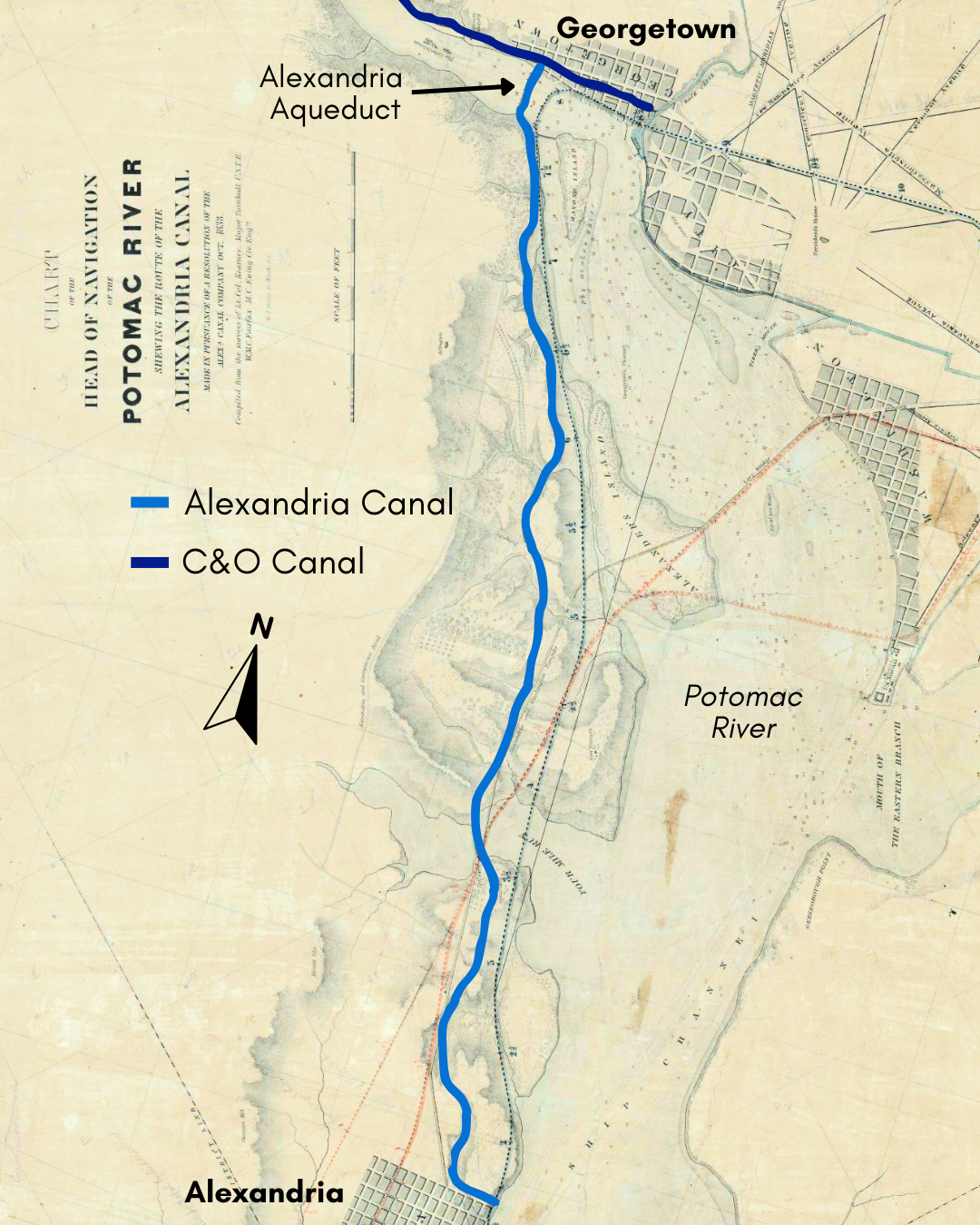
Chart of the head of navigation of the Potomac River shewing the route of the Alexandria Canal: made in pursuance of a resolution of the Alex'a Canal Company Oct. 1838. (Courtesy Library of Congress)

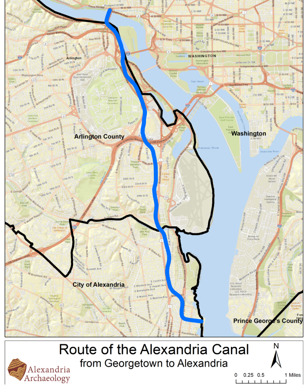
What path did it take?

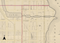
Once complete, the Alexandria Canal was seven miles long. Starting at today’s Tide Lock Park, the canal ran west between Montgomery and First Streets until it reached the Turning Basin near today's Washington Street. There, the canal made its way north towards Georgetown, briefly following today's George Washington Memorial Parkway before veering a bit west to follow a similar path as today's Route 1. The final stretch brought it across the Potomac River on the Aqueduct Bridge to meet with the C&O Canal in Georgetown. Boats would travel the canal in both directions.

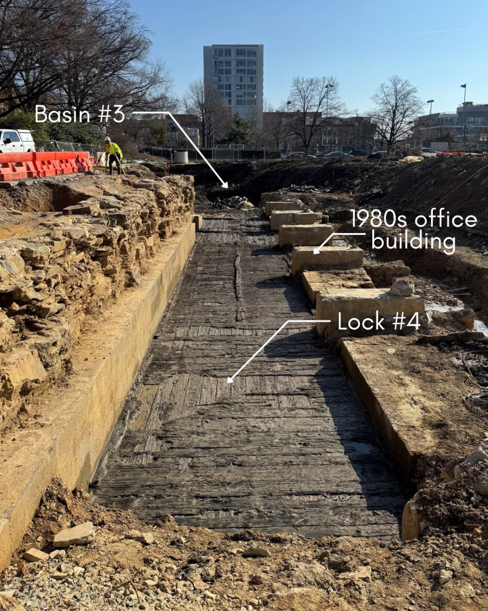
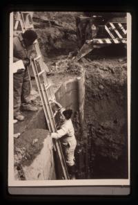
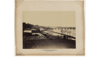
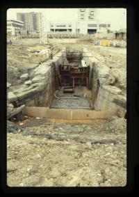
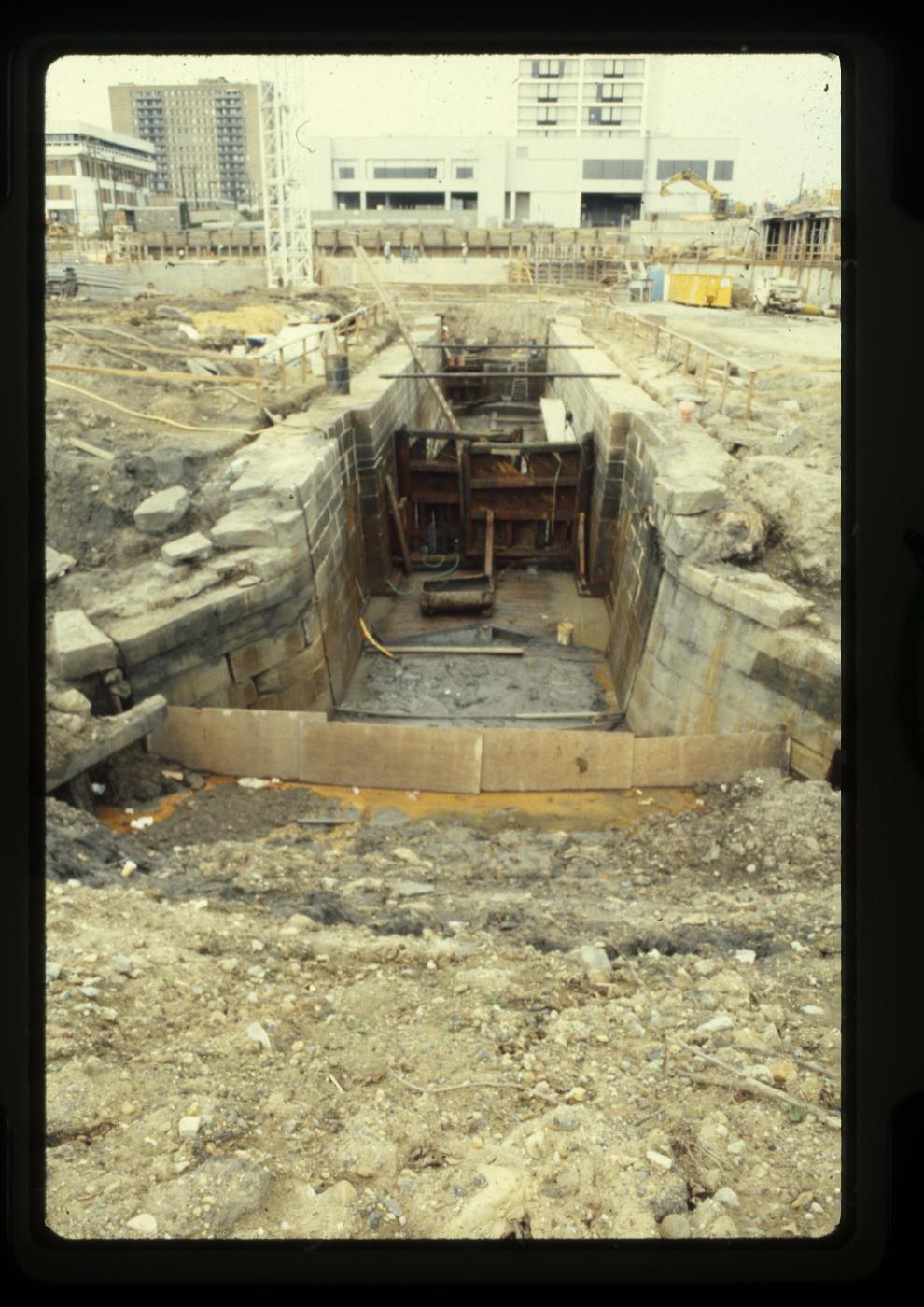
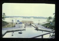
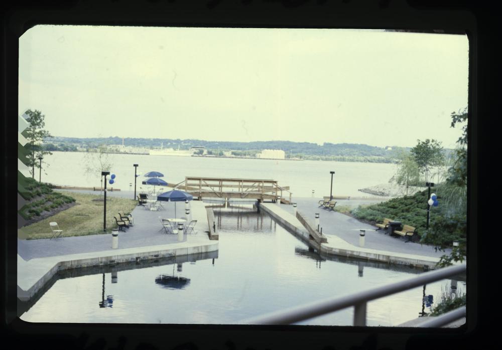
The Alexandria Canal had four locks to manage the 38-foot elevation change between the city’s Potomac River waterfront and the turning basin near Washington and First Street. The 2024-2025 excavation uncovered the westernmost lock at the 900 block of North Pitt Street. In 1979, archaeologists rediscovered the easternmost lock, known as Lift Lock No. 1 or the Tidal Lock, now reconstructed at Tide Lock Park.  

The Alexandria Canal had four basins within city limits. In 2017, archaeologists working at 901 North St. Asaph Street uncovered the remains of the Turning Basin, a wide and shallow pool that allowed canal boats and barges to change direction, load and unload cargo, and wait for passage through the locks. The 2024-2025 excavation at 900 North Pitt Street uncovered a portion of the third basin, directly to the east of the larger turning basin. 

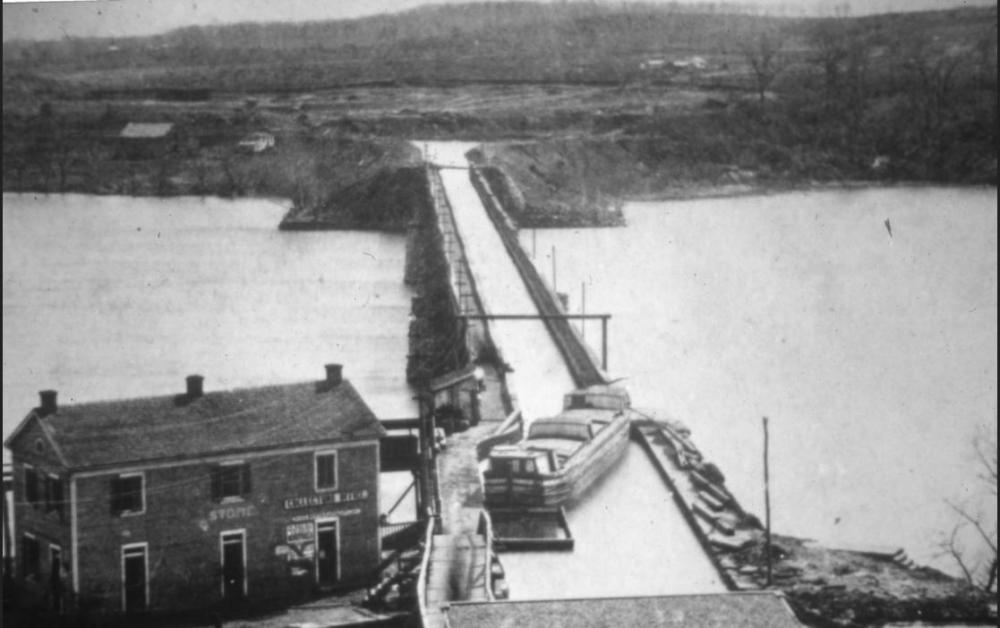
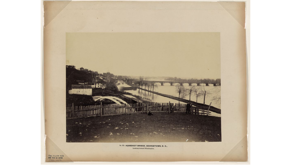
The Aqueduct Bridge, also known as the Alexandria Aqueduct, connected the Alexandria Canal on the western shore of the Potomac to the C&O Canal in Georgetown, crossing above the Potomac River near where the Key Bridge is today. The over 1000-foot span allowed boats to maintain their elevation, rather than descending to the river and then ascending again to the level of the C&O Canal, and allowed the unpowered canal boats to cross the deep and swift river channel. The Alexandria Aqueduct was completed in 1843 and removed in 1923, leaving behind the the remains of the north abutment on the Georgetown side of the Potomac River. 

Modern map showing roads and other points of interest between Alexandria and Georgetown, with an overlay of the original Alexandria Canal route roughly paralleling the Potomac River.
Map of Alexandria in 1877 showing the narrow locks and wider basins of the canal.
Photograph showing three men in Georgetown in the foreground with the Aqueduct Bridge and C&O Canal in the background.
Photo from 1984 excavation showing the canal lock and gate doors.
of
Grid View Close Modal
Modern map showing roads and other points of interest between Alexandria and Georgetown, with an overlay of the original Alexandria Canal route roughly paralleling the Potomac River.
Modern map showing the Alexandria Canal route in dark blue.
Map of Alexandria in 1877 showing the narrow locks and wider basins of the canal.
The Alexandria Canal's four locks and four basins, G.M. Hopkins City Atlas, 1877.
Photograph showing three men in Georgetown in the foreground with the Aqueduct Bridge and C&O Canal in the background.
Aqueduct Bridge in Georgetown, D.C., looking towards Washington. Photograph, ca. 1861-1865, by Andrew J. Russell. (Courtesy of Library of Congress).
Photo from 1984 excavation showing the canal lock and gate doors.
November 1985 excavation of the tide lock (44AX28) showing the preserved gates.

How was it built?

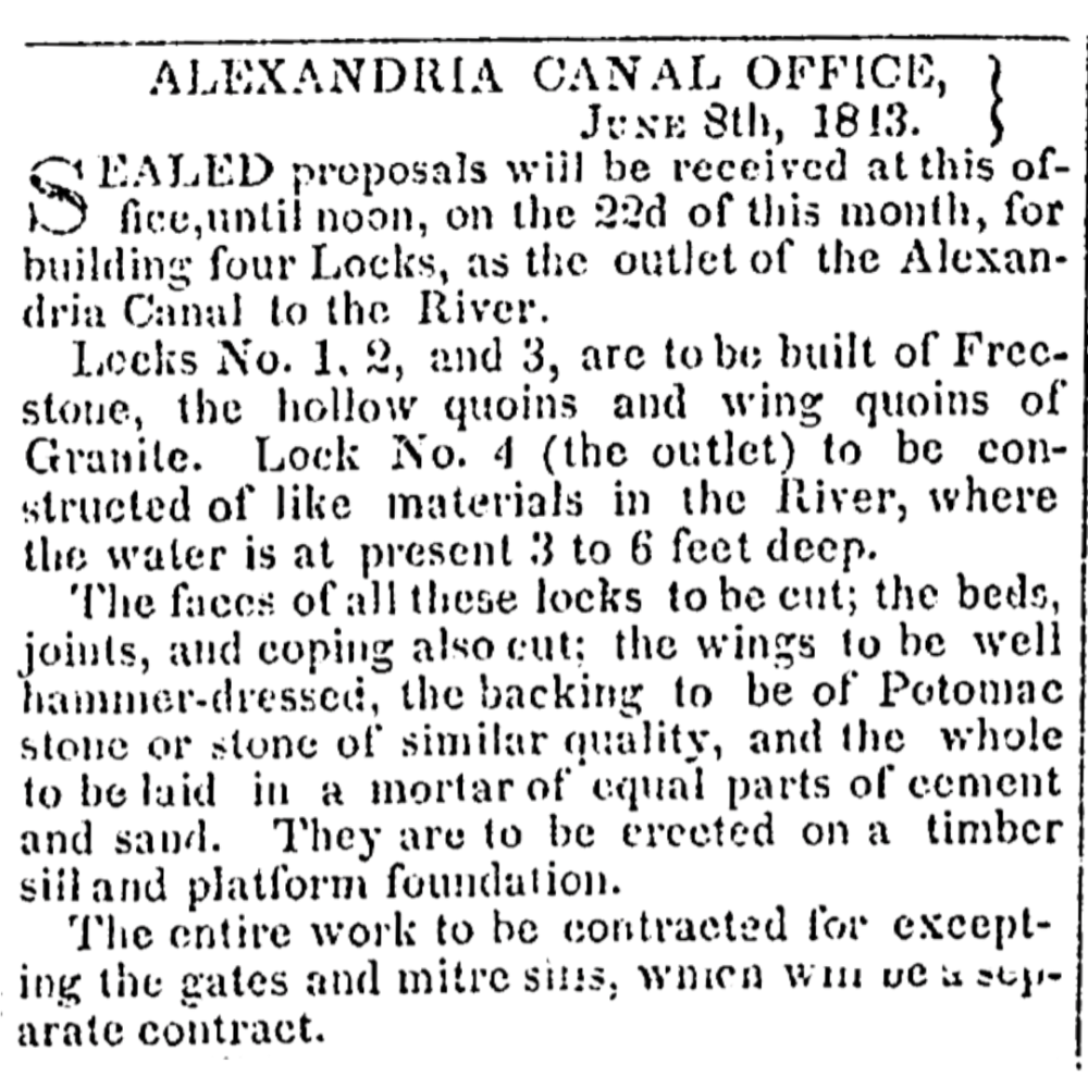
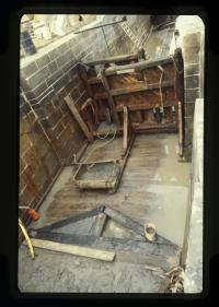
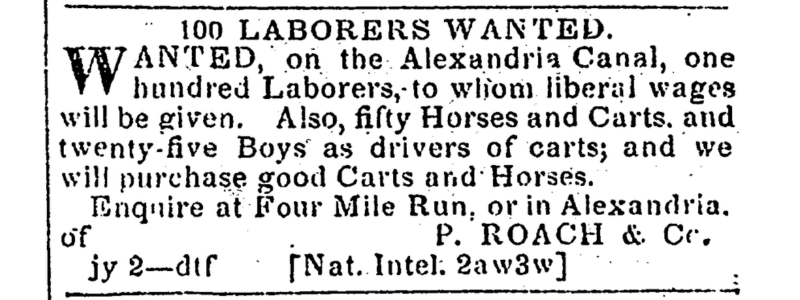
The Alexandria Canal was built largely through the forced labor of enslaved people, as well as paid labor. The majority of the canal was a clay-lined ditch, called a prism, with a towpath on one side for draft animals to pull the boats and barges. The locks were built out of timber, cement and locally available Aquia sandstone. Archaeologists have uncovered portions of the canal and have documented the wood floors, stone walls, and remnants of the lock gates and mitre sills.  

View a 3D model of Lock No. 4 and the third basin

Advertisement from the Alexandria Canal Office on June 8, 1813 asking for "sealed proposals...for building four Locks, as the outlet of the Alexandria Canal to the River." The request for proposals specifies that they should "be built of Freestone...and...Granite," "The faces of all...to be cut; the wings to be well hammer-dressed...and the whole to be laid in a mortar of equal parts of cement and sand."
Advertisement seeking "one hundred Laborers, to whom liberal wages will be given. Also fifty Horses and Carts, and twenty-five Boys as drivers of carts..."
Excavation of canal at 901 N Pitt showing the wooden floor and two layers of canal stones: a rough layer covered by smoother cut stone.
Wooden floor, triangular mitre sill, and lock gates of the excavated tidal lock.
of
Grid View Close Modal
Advertisement from the Alexandria Canal Office on June 8, 1813 asking for "sealed proposals...for building four Locks, as the outlet of the Alexandria Canal to the River." The request for proposals specifies that they should "be built of Freestone...and...Granite," "The faces of all...to be cut; the wings to be well hammer-dressed...and the whole to be laid in a mortar of equal parts of cement and sand."
Advertisement seeking proposals for the construction of the canal locks, Alexandria Gazette, June 8, 1813.
Advertisement seeking "one hundred Laborers, to whom liberal wages will be given. Also fifty Horses and Carts, and twenty-five Boys as drivers of carts..."
Advertisement seeking laborers for the canal, Alexandria Gazette, July 4, 1835
Excavation of canal at 901 N Pitt showing the wooden floor and two layers of canal stones: a rough layer covered by smoother cut stone.
Sandstone wall and wood floor of canal basin, 901 N Pitt Street.
Wooden floor, triangular mitre sill, and lock gates of the excavated tidal lock.
November 1985 excavation of the tide lock (44AX28) showing the preserved wooden floor and mitre sill.

When was the Alexandria Canal in use?

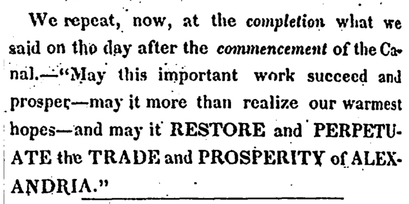
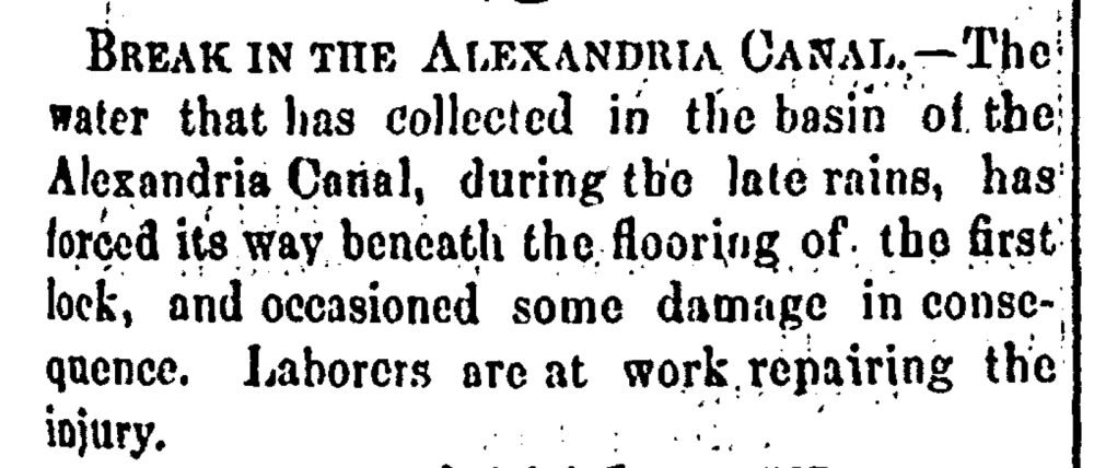
The construction of the Alexandria Canal began in 1831, the year that the Chesapeake & Ohio (C&O) Canal opened. It opened for traffic in Alexandria in 1843 and was completed down to the Potomac River by 1845. The Canal required the aqueduct bridge and the C&O Canal to be in service and all were expensive and difficult to maintain. The Alexandria Canal was out of commission during the Civil War, reopened in 1867, and then ceased operation in 1886 when the Aqueduct Bridge was damaged. By the early 1900s many usable finished or dressed stones from the lock walls had been repurposed and Alexandrians began dumping trash and fill into the former canal. 

Timeline showing that planning started in the late 1700s, the construction started in 1831, it opened in 1843, it expanded to its full length by 1845, and then it closes in 1886.
Newspaper article celebrating the opening of the canal in December 1843. It says, "May this important work succeed and prosper - may it more than realize our warmest hopes - and may it RESTORE and PERPETUATE the TRADE and PROSPERITY of ALEXANDRIA."
Announcement of a "Break in the Alexandria Canal."
Photo taken in 1929 of what remains of the now dry Alexandria Canal as a cut through a small hill with trash scattered at the bottom and a small tree growing in the middle.
of
Grid View Close Modal
Newspaper article celebrating the opening of the canal in December 1843. It says, "May this important work succeed and prosper - may it more than realize our warmest hopes - and may it RESTORE and PERPETUATE the TRADE and PROSPERITY of ALEXANDRIA."
Celebrating the opening of the Alexandria Canal. Alexandria Gazette, December 4, 1843.
Announcement of a "Break in the Alexandria Canal."
Repairs needed for the Alexandria Canal, Alexandria Gazette, November 6, 1867.
Photo taken in 1929 of what remains of the now dry Alexandria Canal as a cut through a small hill with trash scattered at the bottom and a small tree growing in the middle.
Ruins of old Cumberland-Alexandria canal lock at Alexandria, Virginia. J.K. Hillers, 1929.

What did the boats carry?

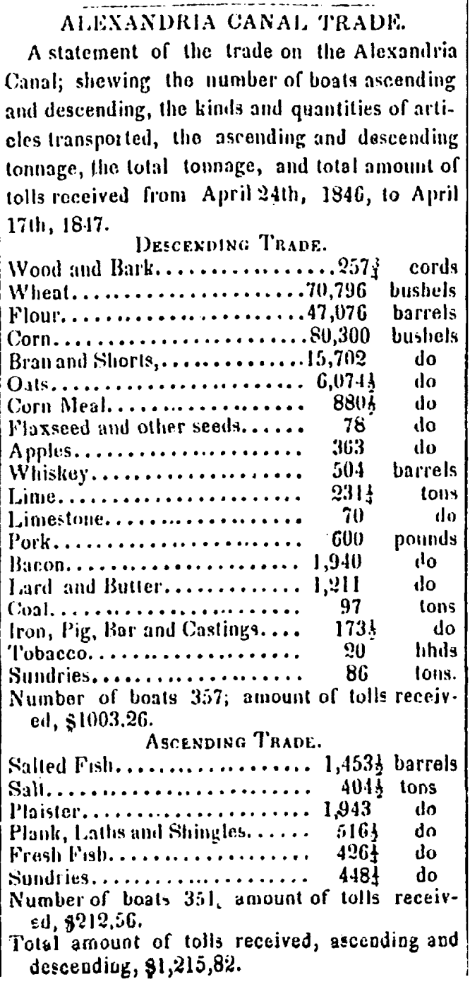
The Alexandria Canal was used mainly for commerce, but was also open for passenger travel. Grain dominated the eastern-bound trade prior to 1850, before being surpassed by coal. Raw goods like stone and timber were also shipped. Some goods stopped in Alexandria, but most were bound for other destinations. Western-bound trade included fish, salt, building materials, guano, and consumer goods. 

List of a variety of canal goods. Imports included wood, wheat, flour, corn, oats, corn meal, flaxseed, apples, whiskey, lime, limestone, pork, bacon, lard and butter, coal, iron, tobacco, and sundries. Exports included salted fish, salt, plaster, plank and shingles, fresh fish, and sundries.
Black and white photo of the coal wharf at the canal's tide lock. Tall ships are shown in the Potomac River in the background. The foreground shows the canal lock and workers at the wharf near piles of coal.
Photo showing a restored park with a walking bridge over a filled pool in the shape of the canal, with the Potomac River in the background.
of
Grid View Close Modal
List of a variety of canal goods. Imports included wood, wheat, flour, corn, oats, corn meal, flaxseed, apples, whiskey, lime, limestone, pork, bacon, lard and butter, coal, iron, tobacco, and sundries. Exports included salted fish, salt, plaster, plank and shingles, fresh fish, and sundries.
List of canal goods shipped through the canal between April 1846 and April 1847, Alexandria Gazette, June 3, 1847.
Black and white photo of the coal wharf at the canal's tide lock. Tall ships are shown in the Potomac River in the background. The foreground shows the canal lock and workers at the wharf near piles of coal.
Alexandria coal wharf with the canal tide lock on the left, works standing next to piles of coal on the right, and sailing ships in the Potomac in the background (Courtesy of National Archives at College Park).
Photo showing a restored park with a walking bridge over a filled pool in the shape of the canal, with the Potomac River in the background.
Restored Tide Lock Park, 1990.

Can I still see the canal?

Archaeologists have excavated portions of the Alexandria Canal. In the late 1970s and into the 1980s, archaeologists uncovered a 90-foot section of the canal, including Lift Lock No. 1 (the tide lock). These archaeological investigations informed the design of present-day Canal Center and its Tide Lock Park, which includes a partially rehabilitated and reconstructed lock. Some canal stones were removed during excavation in 1985, marked with plaques, and placed in public areas throughout the city, including Beatley Central Library, Fort Ward Park, Rivergate Park, and Windmill Hill Park.  

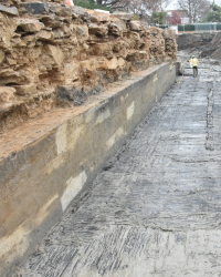
In 2024-2025, archaeologists uncovered the remains of Lock No. 4 and the third basin on the 900 Block of N Pitt Street. Alexandria Archaeology anticipated that the masonry remains of this large-scale piece of historic infrastructure may be preserved despite the development of a 1980s office building, and required the developers hire archaeologists to monitor and document the excavations. A sample of the cut stones were salvaged and stored in adjacent Montgomery Park for eventual re-use within a public waterfront park. View a 3D model of the excavated Lock No. 4 and third basin. 

The canal’s Lock No. 3 and basin two are likely preserved one block to the east, under Montgomery Park. The remains of the north abutment of the aqueduct bridge are still visible on the Georgetown side of the Potomac River.  

Excavated portion of the canal at 901 N Pitt Street, with labels showing the narrow Lock #4, Basin #3 in the background, and remains of the 1980's office building foundation.
An archaeologist climbs a ladder that leans against the inset tide lock gate stone wall.
of
Grid View Close Modal
Excavated portion of the canal at 901 N Pitt Street, with labels showing the narrow Lock #4, Basin #3 in the background, and remains of the 1980's office building foundation.
Excavated sandstone wall and wood floor of Lock #4, looking toward Basin #3, with remnants of the 1980s office building foundation bisecting the south canal wall.
An archaeologist climbs a ladder that leans against the inset tide lock gate stone wall.
Archaeologists excavate the tide lock gate (44AX28), 1982.
  • Archaeology
  • Black History
  • Historic Alexandria
  • Historic Sites
Contact Us
Alex311 | 703.746.4311
Follow Us
  • BlueSky
  • Facebook
  • X
  • YouTube
Visitor Information

VisitAlexandriaVA.com

  • Jobs
  • Payments
  • Departments
  • Newsroom
  • Social Media
  • Emergency Hotlines
  • Accessibility
  • FOIA Requests
  • Privacy & Legal

Alexandria City Hall
301 King Street
Alexandria, VA 22314

City of Alexandria Seal
© 1995–2023 City of Alexandria, VA and others.
Hold on, redirecting...