East Abingdon Drive Bike Lanes Project
Project Description
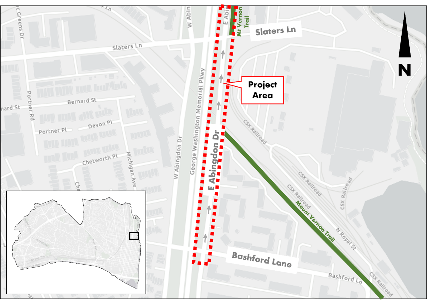
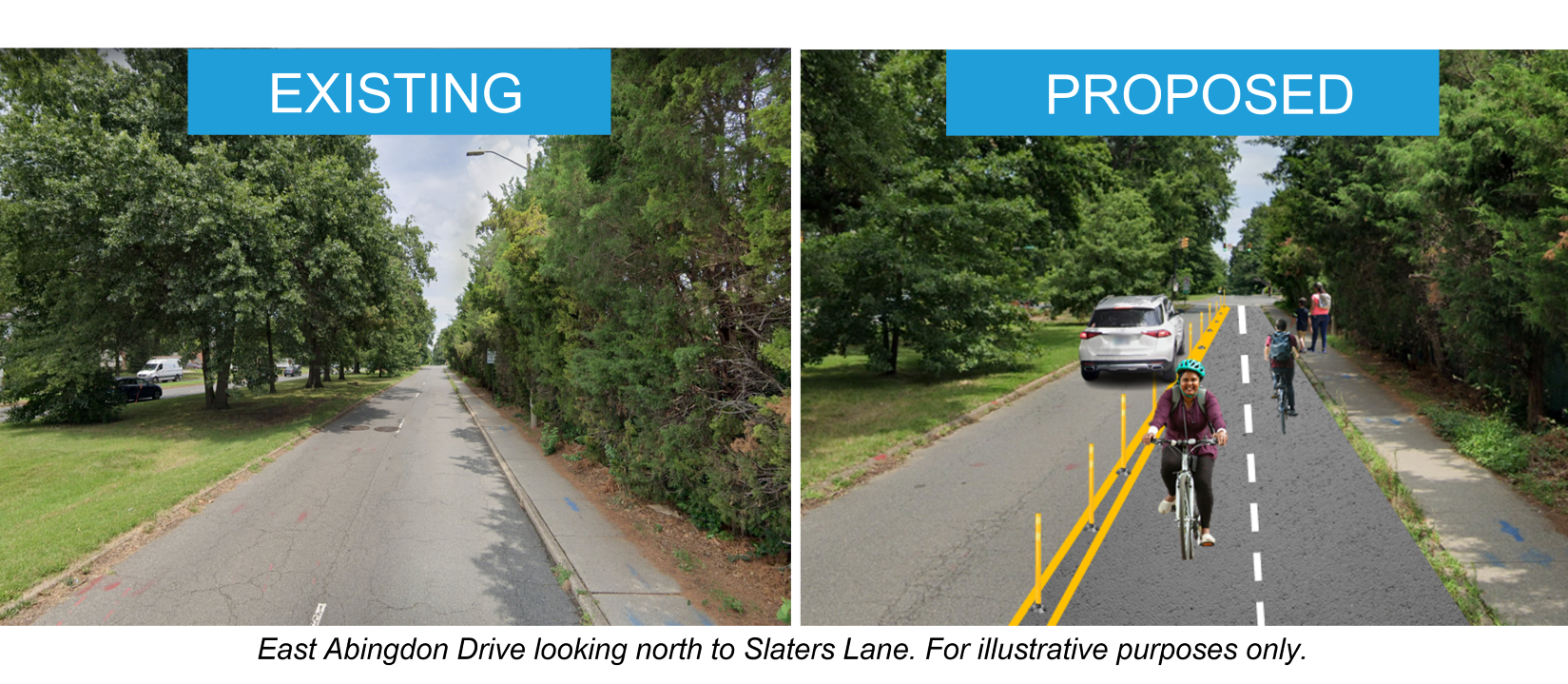
Along East Abingdon Drive, there is a gap of about 600’ in which people walking and biking all share a 4’ wide sidewalk or walk and bike in traffic. The primary purpose of this project is to fill this gap to improve safety and comfort for people walking and biking by providing a two-way bicycle lane on East Abingdon Drive to connect the Mount Vernon Trail. Additionally, this effort is examining and alternative use for the right lane to increase safety and comfort for residents.

Project Development
Overall Project Status: Planning & Design
Community Engagement
Status: In Progress
Summer 2023 Comment Period
The City solicited community feedback on the proposed bike lanes via an online feedback form between August 28 and September 17, 2023. Over 250 comments were received during that period.
Project Presentation
Community Feedback Summary
Thank you for your input!
October 23, 2023 Traffic & Parking Board Public Hearing
The Traffic & Parking Board approved changes to East Abingdon Drive at their October 23 Public Hearing consistent with Option 2. Information is available on the Traffic & Parking Board webpage.
Planning & Design
Status: In Progress
Approved Concept Design: | Option 2

Construction
Status: Not Started
Background
The Mount Vernon Trail is a critical and highly-valued component of the region’s multi-modal transportation system. It provides near-seamless off-street access for people walking and biking for commuting or recreation between Fairfax County, Alexandria, Arlington, and Washington, DC. However, in Alexandria, the trail ends briefly where it meets East Abingdon Drive, a one-way street. Currently, people biking south on the Mount Vernon Trail towards Old Town who are confronted with this can either (a) bike on the narrow sidewalk along East Abingdon, conflicting with people walking, or (b) bike in the street in the wrong direction of traffic. Neither is a safe or comfortable option.
In 2021, the Alexandria City Council adopted the Alexandria Mobility Plan (AMP) to guide the development of the City’s transportation system. A snapshot of the plan identifies the following:
Policy: Prioritize safety: Focus on vulnerable street user crashes to help achieve Vision Zero.
Policy: Address network gaps: Complete pedestrian and bicycle networks equitably and cost-effectively.
Strategy: Create a safe, well-maintained, and comfortable walking and bicycling environment.
Strategy: Build out a connected bicycle network of both on- and off-street facilities to benefit cyclists of all ages and abilities.
The AMP also includes a proposed bicycle network, which calls for completing the connection of the Mount Vernon Trail on East Abingdon Drive.
The goal of this project is to both increase safety and provide residents, visitors and commuters with options for using the Mount Vernon Trail.
Timeline
Community Engagement: Ongoing
Planning & Design: Summer 2023-Spring 2024
Implementation: Summer 2024-Fall 2024*
*Note: Project requires coordination and permitting with the National Park Service. Timeline is subject to change.
Frequently Asked Questions (FAQs)
Why is the City considering this project?
For a long time, the City has recognized this trail gap and recommended addressing it by providing an enhanced bicycle connection. In 2017, the City began planning and designing a separate, but related project to extend the trail from Slaters Lane north to where it currently ends near Salvation Army. This will reduce conflicts between pedestrians, cyclists, and buses.
Because the portion south of Slaters Lane has extremely limited right of way, and because there are no plans to redevelop the Pepco Substation, this portion has been more complicated and would require repurposing a travel lane.
This branch of the Mt. Vernon Trail serves as an important alternative to the waterfront branch of the trail for residents, commuters, and visitors. However, people walking and biking along this stretch are expected to share a four-foot sidewalk. By filling in this gap, the City can increase safety and comfort for people walking and bicycling in Alexandria.
How can I provide input?
Visit the Community Engagement section of this webpage for opportunities to provide input.
Will the project involve removing a travel lane on East Abingdon Drive?
Yes, this project proposes converting one travel lane on East Abingdon Drive to create space for a two-way bike facility.
What does this project mean for the existing HOV lane on East Abingdon Drive?
The bike lanes would replace the HOV lane.
If the Alexandria Mobility Plan calls for an extension of the trail, why are bike lanes being considered?
A two-way bike facility is being considered as a potential interim solution. However, longer-term plans may consider enhanced separated pedestrian and cycling facilities or a shared use path. This may be subject to redevelopment of the Pepco Substation.
How does this project relate to the redevelopment of the former power plant site?
If a bike facility is installed on East Abingdon Drive, it will enhance connectivity, safety, and options for people biking near the former power plant site, which is planned as a walkable, mixed-use, development. However, this project is not associated with the redevelopment of the of the power plant site.
How would this project impact traffic?
Traffic modeling indicates that there could be a minimal impact during the AM rush hour, with drivers experiencing additional queuing on East Abingdon Drive approaching Slaters Lane that might add 10-20 seconds to their trip. No significant impact is expected at other times of the day.